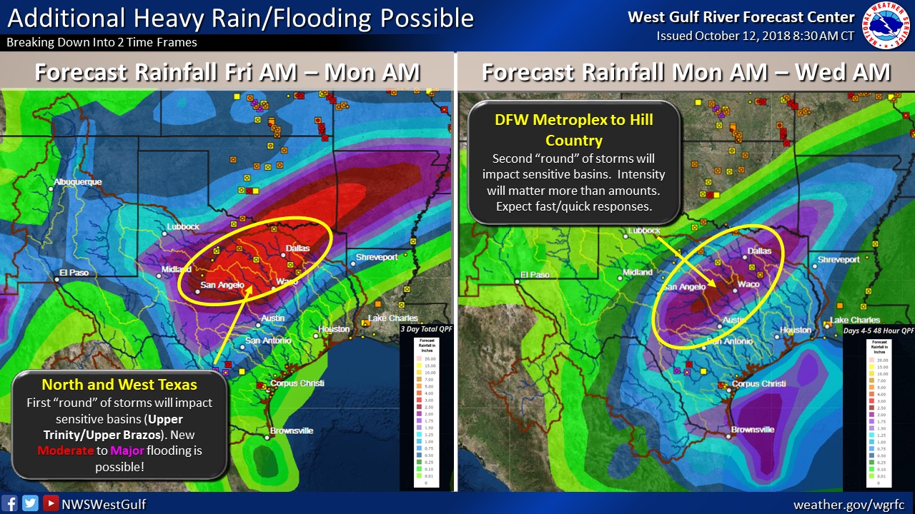
TRWD staff continues to monitor conditions in the District reservoir watersheds 24 hours a day. Much of the Eagle Mountain and Bridgeport watersheds have received 1/2 to 1 inch of rain since midnight. The National Weather Service (NWS) continues to forecast anywhere from 2 to 8 inches of rainfall for the TRWD reservoir watersheds between now and Wednesday morning. The NWS River Forecast Center‘s latest briefing is calling for a possibility of moderate to major river flooding in the Upper Trinity River basin, see below. It should be noted that the locations in the Upper Trinity basin most likely to see these levels of flooding are downstream of Dallas as they are already experiencing elevated river levels from the rainfall earlier this week. Sites in the far Upper Trinity basin such as Jacksboro and Boyd are more likely to see minor flooding, rather than moderate to major flooding. Be sure to follow the River Forecast Center for the latest conditions at these locations.
Current conditions at TRWD reservoirs are shown below. At the moment TRWD monitoring staff is not expecting TRWD reservoirs to fill, however the possibility cannot be ruled out. Please be advised that forecasts are subject to change and TRWD reservoir operations are based on observed rainfall conditions. Additional updates will be provided here if conditions dictate, please check back.
River Forecast Center Guidance

The latest update of reservoir conditions follows:
Lake Bridgeport
- Current reservoir elevation – 830.50 ft-msl.
- Conservation level elevation – 836.00 ft-msl.
- Change in past 24 hours – +0.13 ft.
- Current discharge is 0 cfs.
Eagle Mountain Lake
- Current reservoir elevation – 647.98 ft-msl.
- Conservation level elevation – 649.10 ft-msl.
- Change in past 24 hours – 0.00 ft.
- Current release is 144 cfs.
Lake Worth (owned and operated by the City of Fort Worth)
- Current reservoir elevation – 592.40 ft-msl.
- Conservation level elevation – 594.00 ft-msl.
- Change in past 24 hours – +0.01 ft.
- Current discharge is 0 cfs.
- See City of Fort Worth news feed for updates on lake.
Cedar Creek
- Current reservoir elevation – 320.26 ft-msl.
- Conservation level elevation – 322.00 ft-msl.
- Change in past 24 hours – +0.00 ft.
- Current discharge is 0 cfs.
Richland-Chambers
- Current reservoir elevation – 313.89 ft-msl.
- Conservation level elevation – 315.00 ft-msl.
- Change in past 24 hours – +0.22 ft.
- Current release is 5 cfs (environmental flow).
Please call the Flood Hotline for further information.
817-720-4296.
If prompted to leave a message, the flood monitor on duty will return your call within 30 minutes.
*ft-msl – feet above mean sea level; cfs – cubic feet per second
Post based on conditions as of October 12, 2018, at 3:00 PM