
TRWD staff continues to monitor conditions in the TRWD reservoir watersheds 24 hours a day. Additional rainfall is expected beginning tonight through early Saturday morning. For the latest weather updates follow the National Weather Service (NWS).
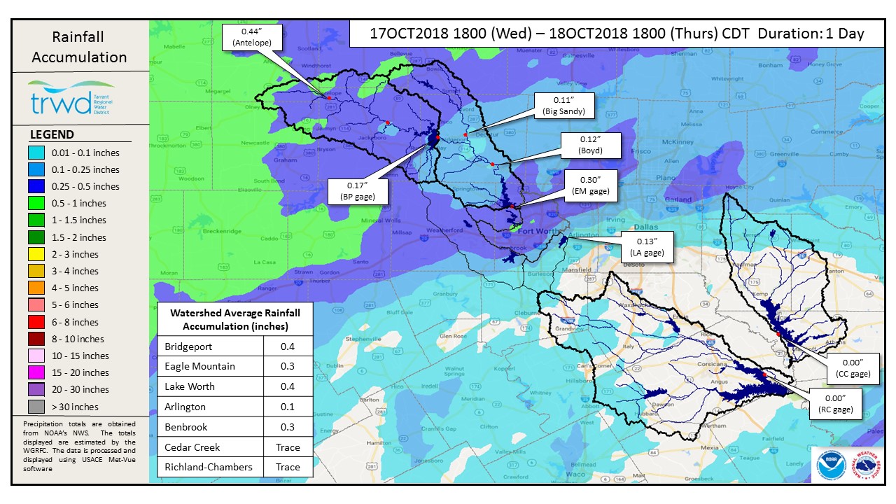
Graphic-1 shows the rainfall received in the past 24 hours in the TRWD reservoir watersheds.
Graphic – 1 TRWD Reservoirs – 24-Hour Rainfall Accumulations
Current river conditions and forecasts from the NWS River Forecast Center can be found at the following links: West Fork Trinity River near Jacksboro, West Fork Trinity River near Boyd, Trinity River at Trinidad, and Chambers Creek near Rice.
The latest reservoir projections follow:
- Bridgeport continues to rise, but is not projected to fill at this time.
- Eagle Mountain has been remaining relatively constant near elevation 649.5, and appears to be slowly decreasing.
- Lake Worth crested at about elevation 594.92 around midnight last night. It is expected for the reservoir to recede back to approximately elevation 594.6 ft-msl where it will remain until discharges from Eagle Mountain are reduced.
- Richland-Chambers is above conservation level. Discharges continue as the reservoir is beginning to crest.
- Cedar Creek is above conservation level. Discharges continue as the reservoir is beginning to crest.
Please be advised that projections are made barring additional rainfall and are subject to change. TRWD reservoir operations are based on observed rainfall conditions. Additional updates will be provided here if conditions dictate. Please check back.
The latest update of reservoir conditions follows:
Lake Bridgeport
- Current reservoir elevation: 832.89 ft-msl.
- Conservation level elevation: 836.00 ft-msl.
- Change in past 24 hours: +0.28 ft.
- Current discharge is 0 cfs.
Eagle Mountain Lake
- Current reservoir elevation: 649.49 ft-msl.
- Conservation level elevation: 649.10 ft-msl.
- Change in past 24 hours: +0.01 ft.
- Current discharge is 770 cfs.
Lake Worth (owned and operated by the City of Fort Worth)
- Current reservoir elevation: 594.69 ft-msl.
- Conservation level elevation: 594.00 ft-msl.
- Change in past 24 hours: -0.03 ft.
- Current discharge is 1,570 cfs.
- See City of Fort Worth news feed for updates on lake.
Cedar Creek
- Current reservoir elevation: 322.41 ft-msl.
- Conservation level elevation: 322.00 ft-msl.
- Change in past 24 hours: +0.01 ft.
- Current discharge is 7,180 cfs.
Richland-Chambers
- Current reservoir elevation: 316.22 ft-msl.
- Conservation level elevation: 315.00 ft-msl.
- Change in past 24 hours: +0.19 ft.
- Current discharge is 15,180 cfs.
Please call the Flood Hotline for further information.
817-720-4296.
If prompted to leave a message, the flood monitor on duty will return your call within 30 minutes.
*ft-msl – feet above mean sea level; cfs – cubic feet per second
Post based on conditions as of October 18, 2018, at 8:00 PM