TRWD staff continues to monitor conditions in the TRWD reservoir watersheds 24 hours a day. Additional rainfall is expected today and tomorrow. For the latest weather updates follow the National Weather Service (NWS).
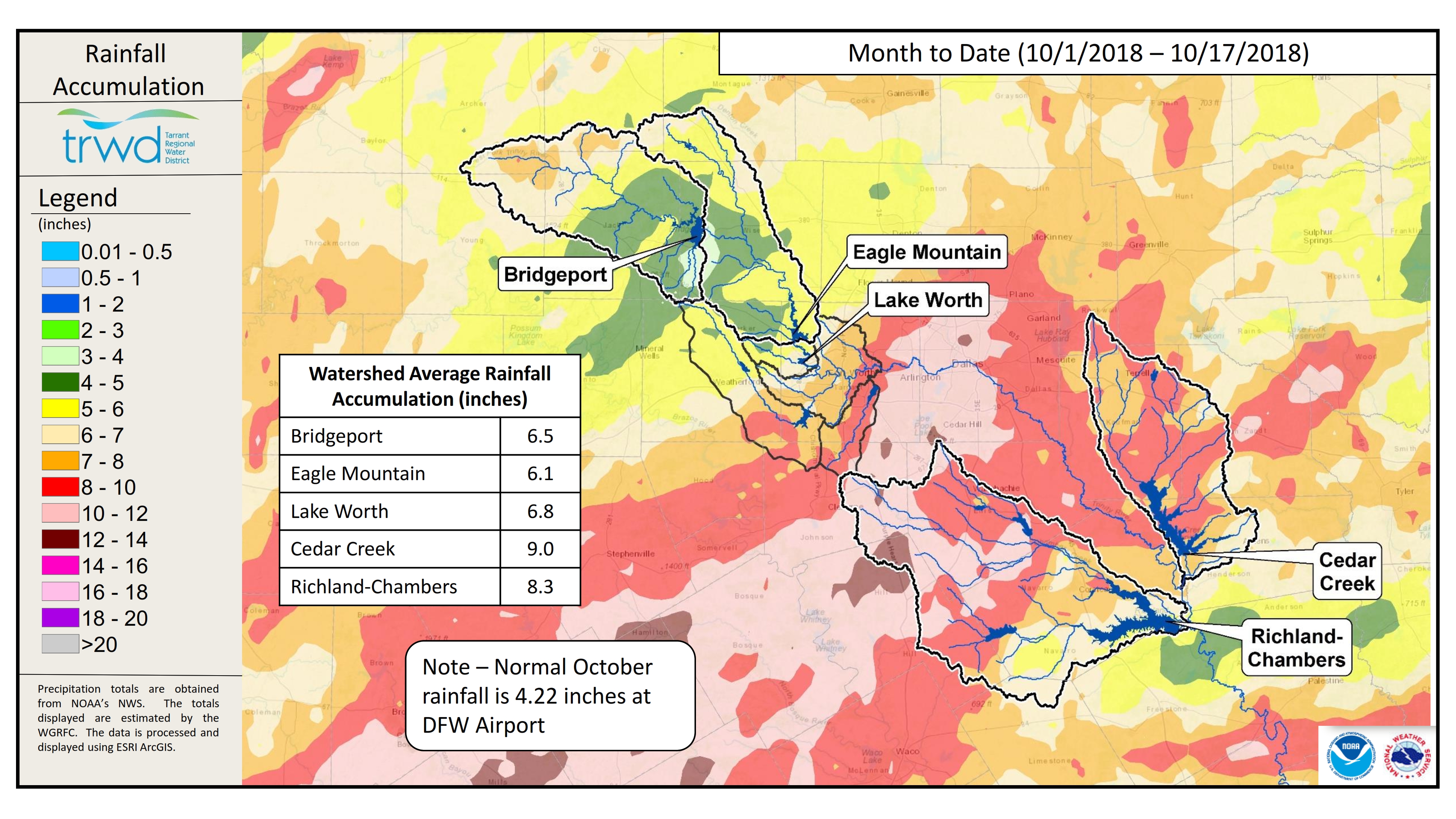
The following graphics put into perspective how wet this October has been. Graphic-1 shows the rainfall recieved so far this month in the TRWD reservoir watersheds. Note that the watersheds have already received 150 to 200% of the normal rainfall total for the month.
Graphic – 1 TRWD Reservoir – Month to Date Rain Totals
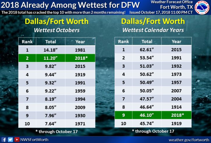
Graphic-2 was prepared by the NWS and shows that October 2018 is already the 2nd wettest October on record and the calendar year is now in the Top 10 for wettest years on record.
Graphic-2. NWS Rainfall Summary
Current river conditions and forecasts from the NWS River Forecast Center can be found at the following links: West Fork Trinity River near Jacksboro, West Fork Trinity River near Boyd, Trinity River at Trinidad, and Chambers Creek near Rice.
The latest reservoir projections follow:
- Bridgeport continues to rise, but is not projected to fill at this time.
- Yesterday’s additional rainfall at Eagle Mountain has pushed the level over the previous projection of 649.5 ft-msl. The reservoir level is expected to start receding today.
- Lake Worth has received some localized rainfall that has pushed it slightly above elevation 594.7 ft-msl. It is expected for the reservoir to recede back to approximately elevation 594.6 ft-msl where it will remain until discharges from Eagle Mountain are reduced.
- Richland-Chambers is above conservation level. Discharges continue as the reservoir is beginning to crest.
- Cedar Creek is above conservation level. Discharges continue as the reservoir is beginning to crest.
Please be advised that projections are made barring additional rainfall and are subject to change. TRWD reservoir operations are based on observed rainfall conditions. Additional updates will be provided here if conditions dictate. Please check back.
The latest update of reservoir conditions follows:
Lake Bridgeport
- Current reservoir elevation: 832.74 ft-msl.
- Conservation level elevation: 836.00 ft-msl.
- Change in past 24 hours: +0.40 ft.
- Current discharge is 0 cfs.
Eagle Mountain Lake
- Current reservoir elevation: 649.56 ft-msl.
- Conservation level elevation: 649.10 ft-msl.
- Change in past 24 hours: +0.07 ft.
- Current discharge is 790 cfs.
Lake Worth (owned and operated by the City of Fort Worth)
- Current reservoir elevation: 594.89 ft-msl.
- Conservation level elevation: 594.00 ft-msl.
- Change in past 24 hours: +0.36 ft.
- Current discharge is 2,190 cfs.
- See City of Fort Worth news feed for updates on lake.
Cedar Creek
- Current reservoir elevation: 322.41 ft-msl.
- Conservation level elevation: 322.00 ft-msl.
- Change in past 24 hours: +0.18 ft.
- Current discharge is 7,180 cfs.
Richland-Chambers
- Current reservoir elevation: 316.14 ft-msl.
- Conservation level elevation: 315.00 ft-msl.
- Change in past 24 hours: +0.33 ft.
- Current discharge is 15,150 cfs.
Please call the Flood Hotline for further information.
817-720-4296.
If prompted to leave a message, the flood monitor on duty will return your call within 30 minutes.
*ft-msl – feet above mean sea level; cfs – cubic feet per second
Post based on conditions as of October 18, 2018, at 6:00 AM