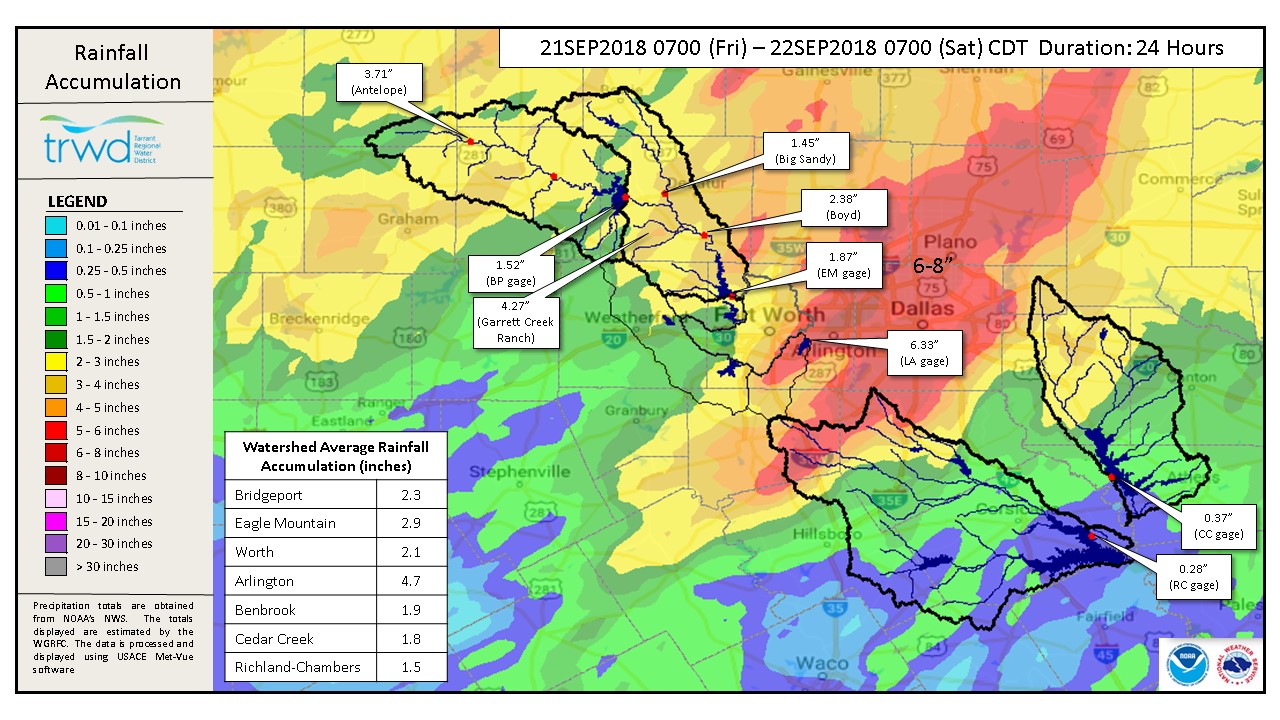
TRWD staff continues to monitor conditions in the TRWD reservoir watersheds 24 hours a day. There was heavy rainfall across the TRWD’s reservoir watershed area overnight, see 24-hour Rain Map below. As much as 4.27 inches of rain was recorded at the TRWD’s Garrett Creek Ranch gauge, west of Boyd. As seen in the map, the bulk of the rain missed the TRWD reservoir watersheds. Lake Arlington recorded 6.33 inches of rain and DFW Airport recorded 7.48 inches. According to the NWS, this makes September 2018 the wettest September on record and this storm is #3 all-time for 24-hour rainfall. At this time monitoring staff is not expecting any of the District Reservoirs to reach conservation level. Please be advised that forecasts are subject to change and District reservoir forecasts and operations are based on observed rainfall conditions. Additional updates will be provided here if conditions dictate, please check back.
24-Hour Observed Rainfall Map

Lake Bridgeport
- Current reservoir elevation – 829.32 ft-msl.
- Conservation level elevation – 836.00 ft-msl.
- Current discharge is 0 cfs.
Eagle Mountain Lake
- Current reservoir elevation – 647.32 ft-msl.
- Conservation level elevation – 649.10 ft-msl.
- Current discharge is 0 cfs.
Lake Worth (owned and operated by the City of Fort Worth)
- Current reservoir elevation – 592.41 ft-msl.
- Conservation level elevation – 594.00 ft-msl.
- Current discharge is 0 cfs.
- See City of Fort Worth news feed for updates on lake
Cedar Creek
- Current reservoir elevation – 319.74 ft-msl.
- Conservation level elevation – 322.00 ft-msl.
- Current discharge is 0 cfs.
Richland-Chambers
- Current reservoir elevation – 312.91 ft-msl.
- Conservation level elevation – 315.00 ft-msl.
- Current discharge is 0 cfs
Please call the Flood Hotline for further information.
817-720-4296.
If prompted to leave a message, the flood monitor on duty will return your call within 30 minutes.
*ft-msl – feet above mean sea level; cfs – cubic feet per second
Post based on conditions as of September 22, 2018, at 8:00 AM