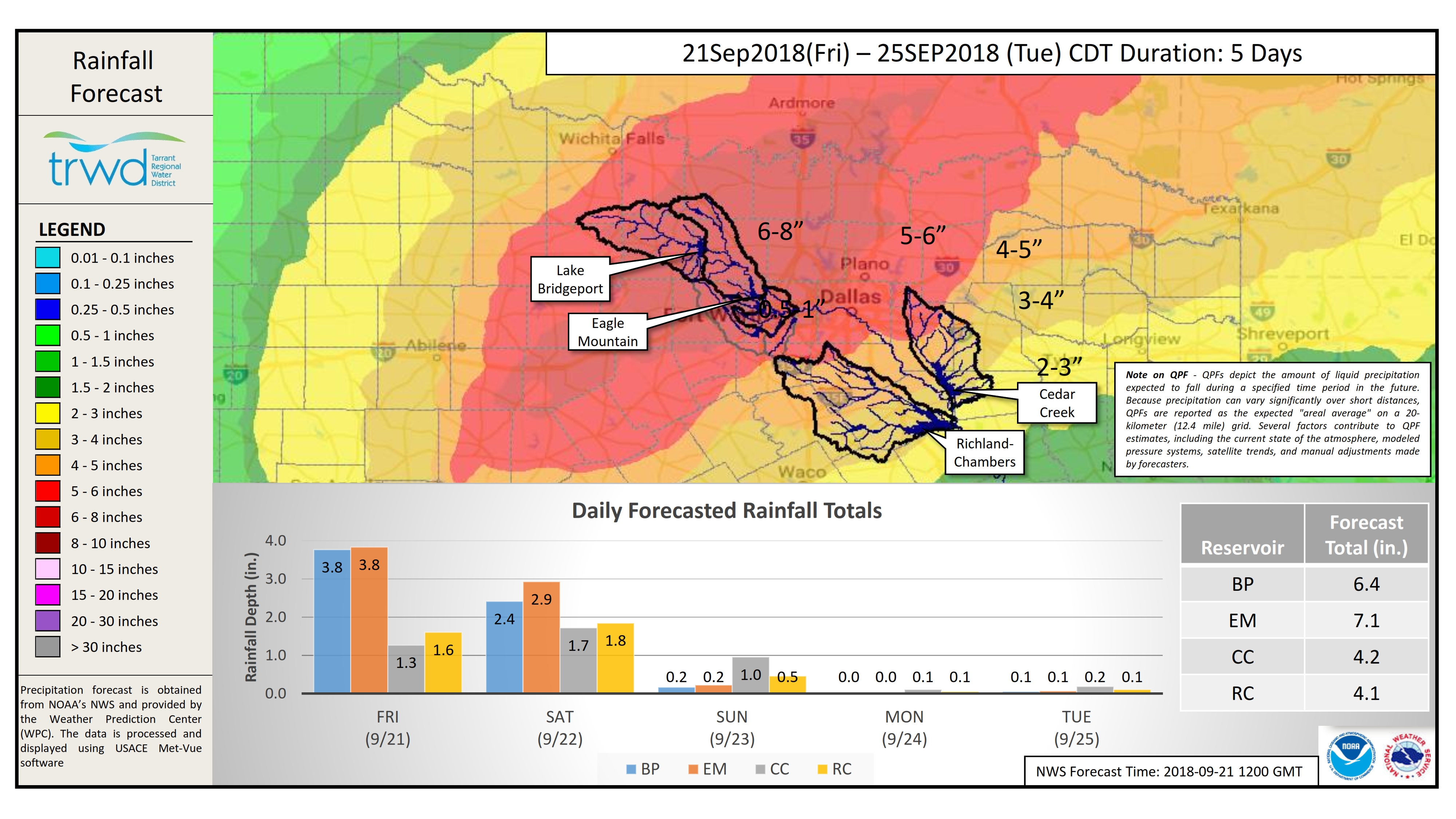
The National Weather Service (NWS) is forecasting heavy rainfall in the TRWD reservoir watersheds. The NWS River Forecast Center‘s latest briefing is calling for a possibility of minor to moderate river flooding in the upper Trinity River basin, see below. Rainfall is expected to start today and should start to taper off by Sunday. Heaviest rainfall totals are expected tonight into Saturday morning. The latest forecasts are predicting 6-10 inches of rain in the Eagle Mountain and Bridgeport watersheds and 2-5 inches in the Richland-Chambers and Cedar Creek watersheds, see 5-day Rainfall Forecast Map below. Current conditions at TRWD reservoirs are shown below. At the moment TRWD monitoring staff is not expecting TRWD reservoirs to fill, however the possibility cannot be ruled out. TRWD staff will be monitoring conditions 24 hours a day. Please be advised that forecasts are subject to change and TRWD reservoir operations are based on observed rainfall conditions. Additional updates will be provided here if conditions dictate, please check back.
River Forecast Center Guidance
5-Day Rainfall Forecast

The latest update of reservoir conditions follows:
Lake Bridgeport
- Current reservoir elevation – 829.99 ft-msl.
- Conservation level elevation – 836.00 ft-msl.
- Current discharge is 0 cfs.
Eagle Mountain Lake
- Current reservoir elevation – 646.52 ft-msl.
- Conservation level elevation – 649.10 ft-msl.
- Current discharge is 0 cfs.
Lake Worth (owned and operated by the City of Fort Worth)
- Current reservoir elevation – 592.05 ft-msl.
- Conservation level elevation – 594.00 ft-msl.
- Current discharge is 0 cfs.
- See City of Fort Worth news feed for updates on lake
Cedar Creek
- Current reservoir elevation – 319.72 ft-msl.
- Conservation level elevation – 322.00 ft-msl.
- Current discharge is 0 cfs.
Richland-Chambers
- Current reservoir elevation – 312.89 ft-msl.
- Conservation level elevation – 315.00 ft-msl.
- Current discharge is 0 cfs
Please call the Flood Hotline for further information.
817-720-4296.
If prompted to leave a message, the flood monitor on duty will return your call within 30 minutes.
*ft-msl – feet above mean sea level; cfs – cubic feet per second
Post based on conditions as of September 9, 2018, at 9:00 AM