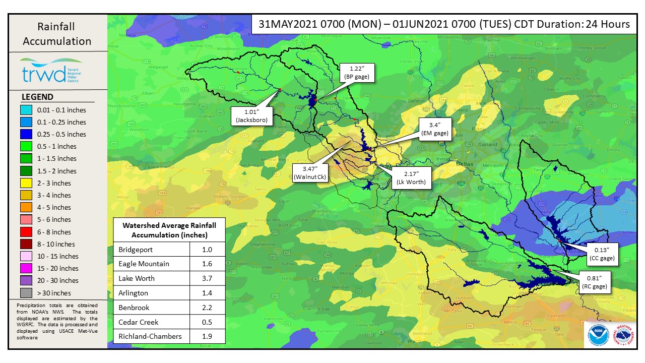
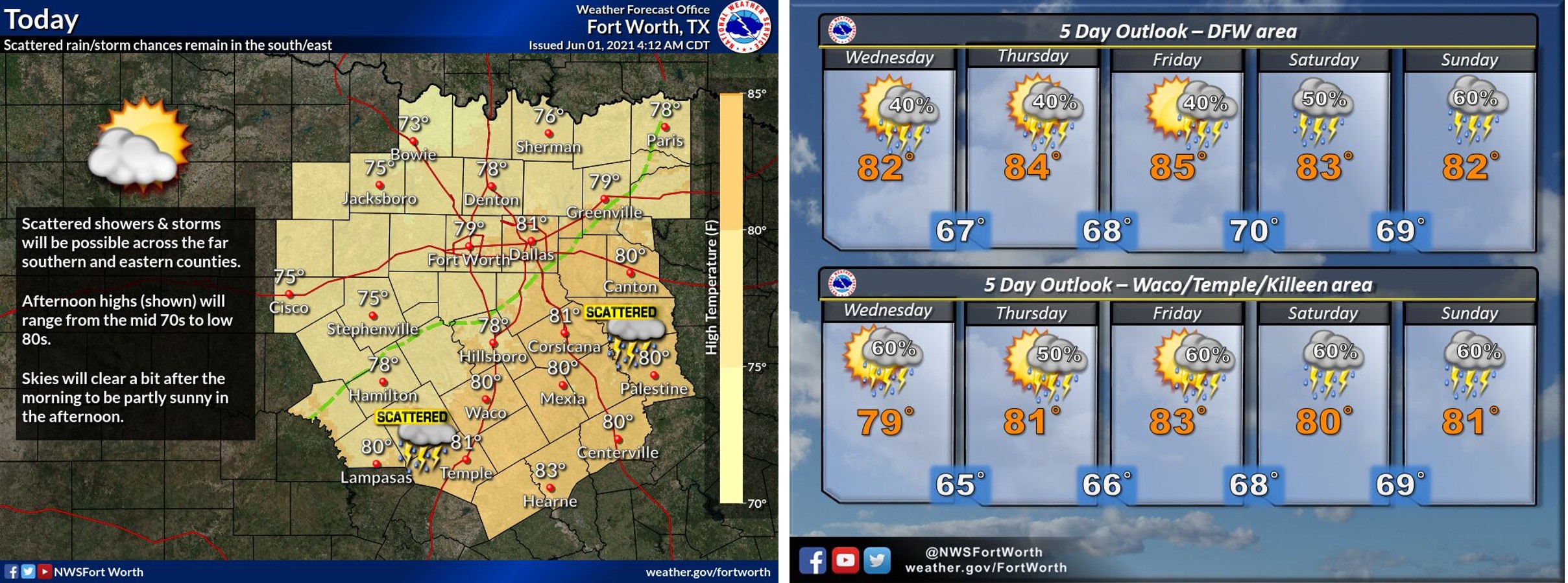
TRWD continues to monitor reservoir conditions 24 hours a day. Inflows have begun to recede at Eagle Mountain and the pool has crested from yesterday’s rainfall. Since last night’s post the rainfall focus shifted to Richland-Chambers, where nearly 2 more inches of rain fell. See Graphic-1 below for 24-hour rainfall totals. Today is expected to be mostly dry in the Bridgeport and Eagle Mountain areas, with scattered showers in the Cedar Creek and Richland-Chambers areas. Past today, it is expected to be wet and cool with some sort of rain chance each day through Sunday. See Graphic-2 for NWS guidance on today and the remainder of the week.
Current reservoir conditions are shown below. Discharges continue at Eagle Mountain, but will be reduced over the coming days as inflow and additional rainfall will allow. Richland-Chambers and Cedar Creek continue to make flood discharges. Bridgeport has reached conservation pool for the first time in 317 days! July 19, 2020 was the last time the lake level was above 836 ft-msl. Discharges from Bridgeport are likely to start as early as today. Staff will continue to monitor conditions and make discharges as needed to safely move excess water through the system. Updates to lake status and flood discharges will be posted here.
Please be advised that forecasts and projections are subject to change, and TRWD reservoir operations are based on observed rainfall conditions. The next update will come this evening, unless conditions dictate otherwise. Please check back. You can also follow @TRWD_News on Twitter to receive notification of any new posts to this Lake Level blog.
Current lake levels can be found in a variety of locations including TRWD.com, the TRWD watershed data viewer trwd.onerain.com, or download the TRWD Lake Level App for iOS or Android. You may also follow the National Weather Service (NWS) and the River Forecast Center (RFC) for the latest information regarding weather and river conditions, respectively.
Graphic-1. 24-Hour Rainfall Accumulation
Graphic-2. NWS Guidance – Today through Sunday
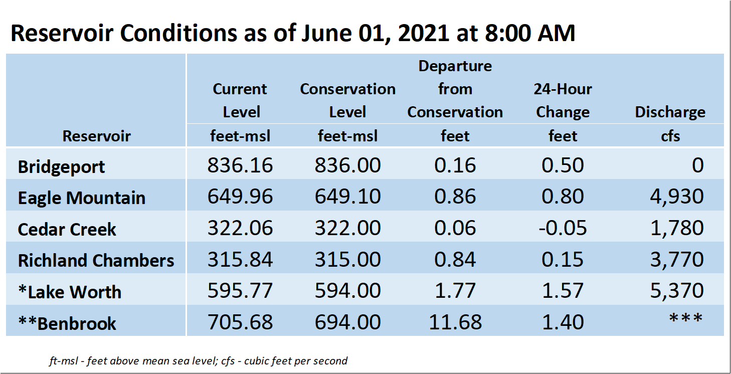
*Lake Worth is owned and operated by the City of Fort Worth. See the City of Fort Worth news feed and NWS forecast page for updates on Lake Worth.
**Benbrook Lake is owned and operated by the U.S. Army Corps of Engineers. ***See Benbrook Lake Home Page for current discharge.
****Please visit TRWD’s new watershed data viewer at www.trwd.onerain.com . You can see the same rain, stream, and lake gages the Flood Team monitors during an event. You can also check out this YouTube video to see what it is all about!
Please call the Flood Hotline for further information.
817-720-4296
If prompted to leave a message, the flood monitor on duty will return your message within 30 minutes.
Posted by CO.