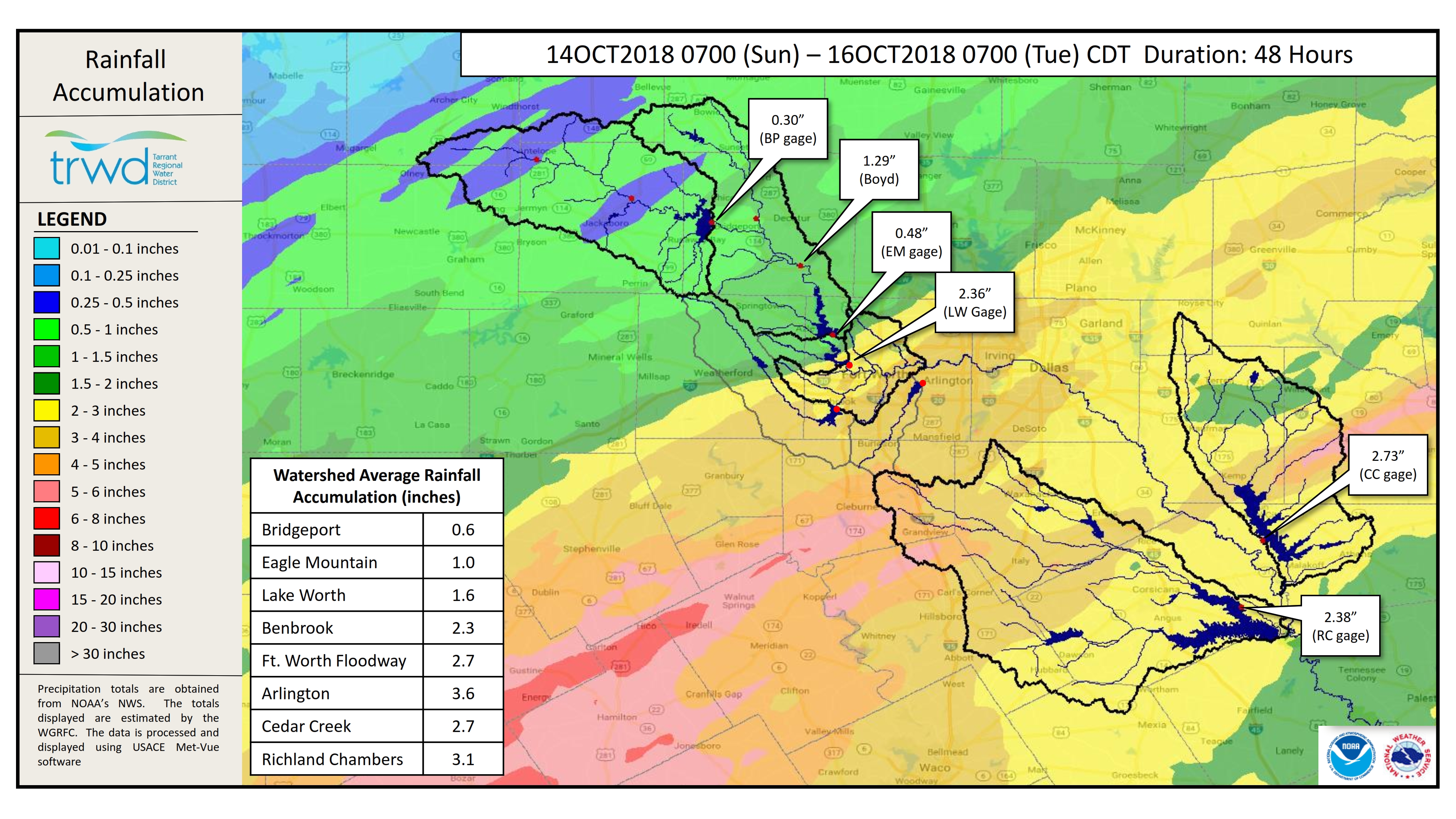
TRWD staff continues to monitor conditions in the TRWD reservoir watersheds 24 hours a day. Graphic-1 below shows the past 24 hours of rainfall across TRWD reservoir watersheds. Light to moderate rainfall is expected to continue overnight, with possible rainfall depths between 0.5”-1”. The metroplex and part of the Eagle Mountain watershed will remain under a Flood Watch until 7 AM tomorrow morning, with possible localized rainfall depths of 1-2”. For the latest weather updates follow the latest National Weather Service (NWS).
River levels at the West Fork Trinity River Jacksboro and Boyd gage sites have crested for the time being. The Jacksboro gage is still within the Action Stage as defined by NWS River Forecast Center; however, the Boyd gage has fallen below this threshold. Use the linked names to follow the latest at these sites.
In the Richland-Chambers area, the Trinity River at Trinidad is currently in Minor Flood Stage and projected to reach Moderate Flood Stage by Saturday. Chambers Creek near Rice is currently increasing, and about to cross the threshold between Moderate and Major Flood Stage. Use the links to access the latest forecast information from the River Forecast Center for these sites.
The latest reservoir projections follow: Eagle Mountain is above conservation level and discharging approximately 760 cfs. At this time Eagle Mountain is not expected to exceed 649.6 ft-msl, barring additional rainfall. Lake Worth is full as of 8:00 AM this morning. At this time Lake Worth is not expected to exceed 594.7 ft-msl, barring additional rainfall. Richland-Chambers was full as of 4:00 AM today. Discharges began earlier today and are currently at approximately 3,740 cfs.
Bridgeport continues to rise, but is not projected to fill at this time. Cedar Creek was full as of about 7:00 PM this evening. Low level discharges began at 9:00 PM. Please be advised that forecasts are subject to change and TRWD reservoir operations are based on observed rainfall conditions. Additional updates will be provided here if conditions dictate. Please check back.
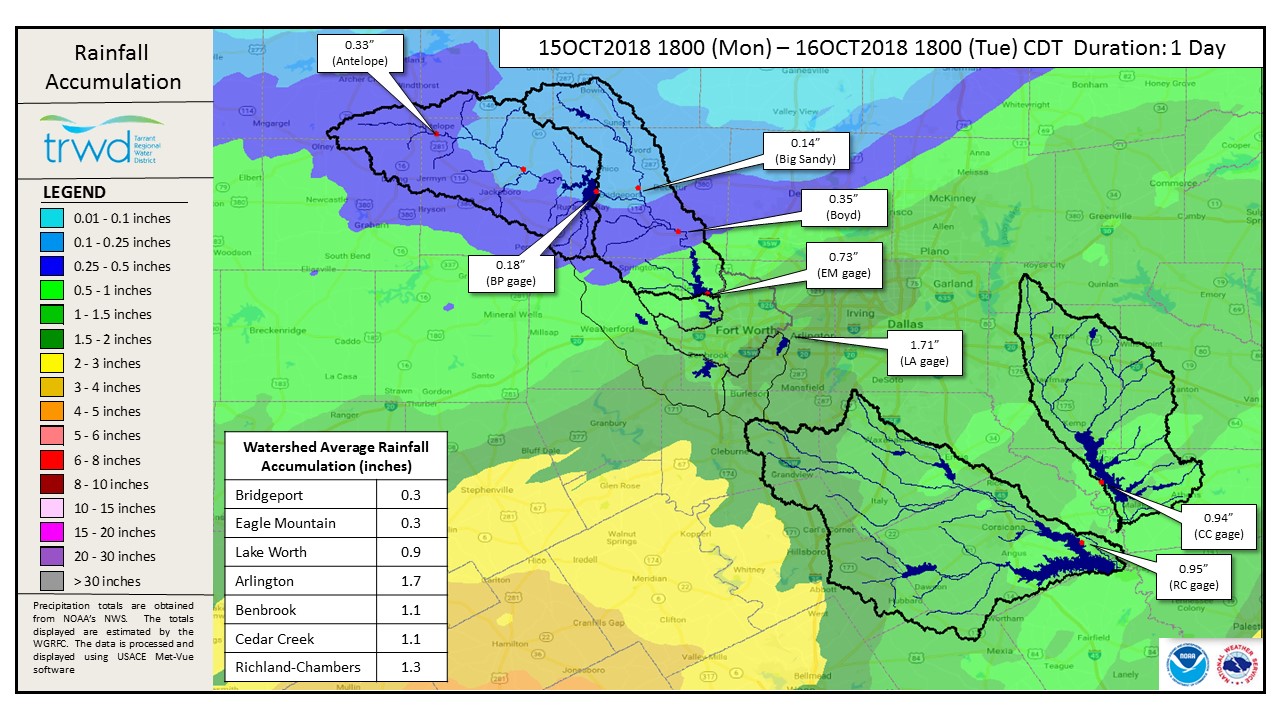
Current conditions at TRWD reservoirs are shown below.
Graphic-1. 24-Hour Rain Totals

The latest update of reservoir conditions follows:
Lake Bridgeport
- Current reservoir elevation: 832.16 ft-msl.
- Conservation level elevation: 836.00 ft-msl.
- Change in past 24 hours: +0.39 ft.
- Current discharge is 0 cfs.
Eagle Mountain Lake
- Current reservoir elevation: 649.46 ft-msl.
- Conservation level elevation: 649.10 ft-msl.
- Change in past 24 hours: +0.26 ft.
- Current discharge is 760 cfs.
Lake Worth (owned and operated by the City of Fort Worth)
- Current reservoir elevation: 594.42 ft-msl.
- Conservation level elevation: 594.00 ft-msl.
- Change in past 24 hours: +0.90 ft.
- Current discharge is 860 cfs.
- See City of Fort Worth news feed for updates on lake.
Cedar Creek
- Current reservoir elevation: 322.03 ft-msl.
- Conservation level elevation: 322.00 ft-msl.
- Change in past 24 hours: +0.62 ft.
- Current discharge is 1,779 cfs.
Richland-Chambers
- Current reservoir elevation: 315.52 ft-msl.
- Conservation level elevation: 315.00 ft-msl.
- Change in past 24 hours: +0.74 ft.
- Current discharge is 3,750 cfs.
Please call the Flood Hotline for further information.
817-720-4296.
If prompted to leave a message, the flood monitor on duty will return your call within 30 minutes.
*ft-msl – feet above mean sea level; cfs – cubic feet per second
Post based on conditions as of October 16, 2018, at 7:00 PM