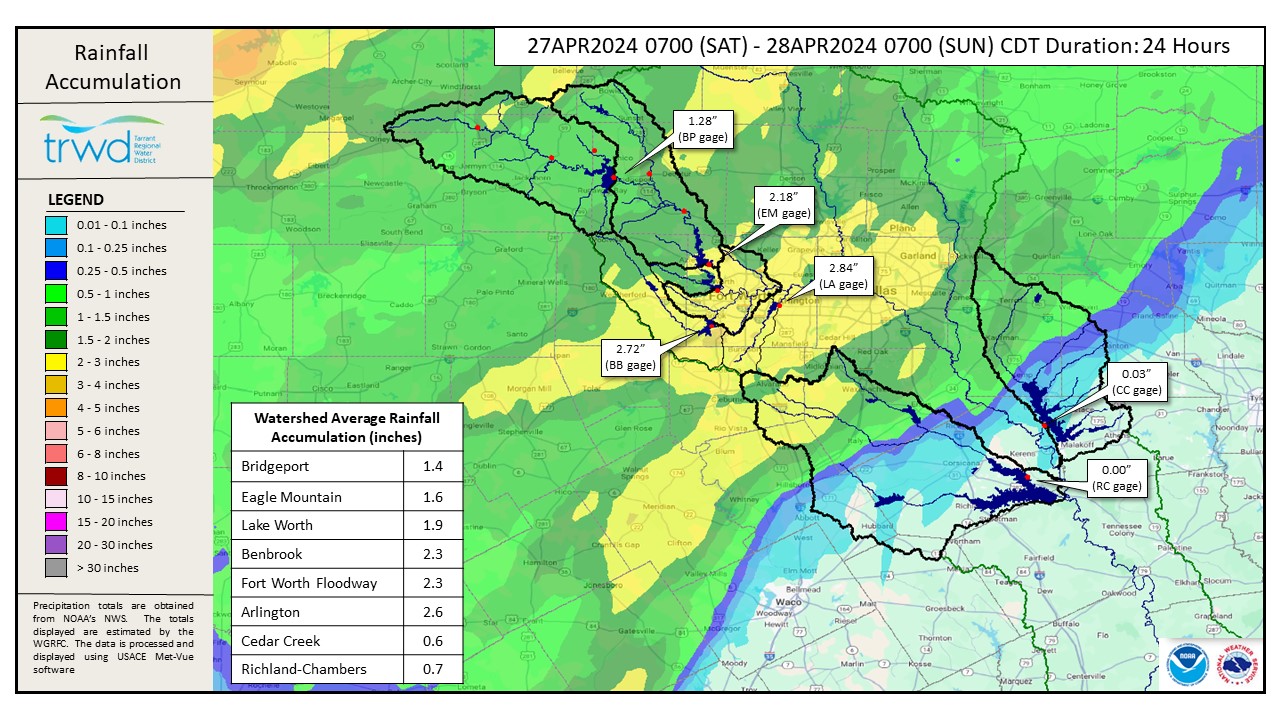
Another round of storms brought additional rainfall for the TRWD West Fork lakes (Bridgeport and Eagle Mountain) overnight and continues to move through the East Texas (ET) lakes (Richland-Chambers and Cedar Creek) this morning. See rainfall depths from the past 24 hours through 7am in Graphic 1 below. This rainfall map is not final for the event as rain is still falling in ET.
Flood Releases
Both ET lakes are above conservation and releasing runoff from Friday’s rainfall event that has now made its way to the lake. Reservoir staff is monitoring this inflow and the incoming rain fall to manage lake levels and downstream conditions as safe as possible. The West Fork lakes (Bridgeport and Eagle Mountain) have plenty of room to store the runoff generated by the rain.
It should be noted that the Cedar Creek gage near Kemp, TX, which contributes to Cedar Creek reached a Top 10 recorded flow rate yesterday when it reached 11,100 cfs. This is the highest it has been since December 2015 when it reached 12,900 cfs. This is where the bulk of the overnight inflow to Cedar Creek is coming from.
Outlook
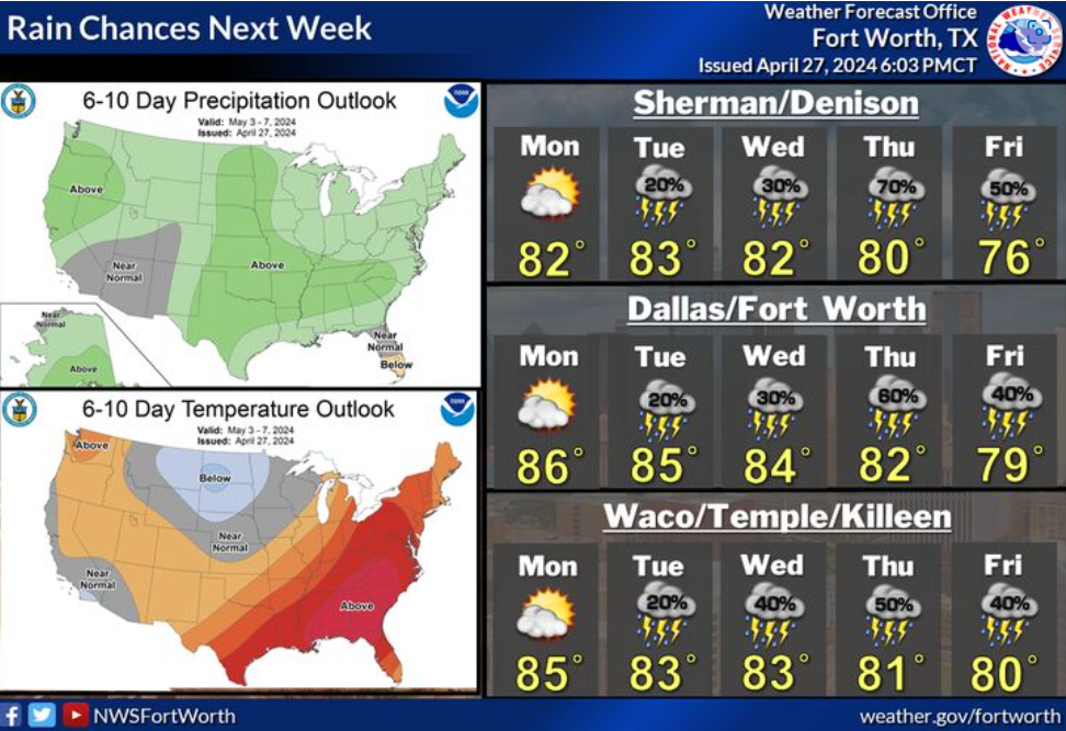
Rainfall should move out of the area by Sunday evening. Storm chances will return on Tuesday and continue the rest of next week. See NWS Guidance below in Graphic-2.
Another update will be provided tomorrow as we continue monitoring rising inflows and lake levels.
Graphic-1. Rainfall Totals from the past 24-hours
 Graphic-2. NWS Guidance
Follow our partners at the National Weather Service (NWS) and the River Forecast Center (RFC) for the latest information regarding weather and river conditions, respectively.
Current TRWD lake conditions are shown below. Be sure to subscribe to receive e-mail notification of any new Lake Level Blog posts. You can also follow @TRWD_News on X (formerly known as Twitter) to receive Lake Level blog notifications.
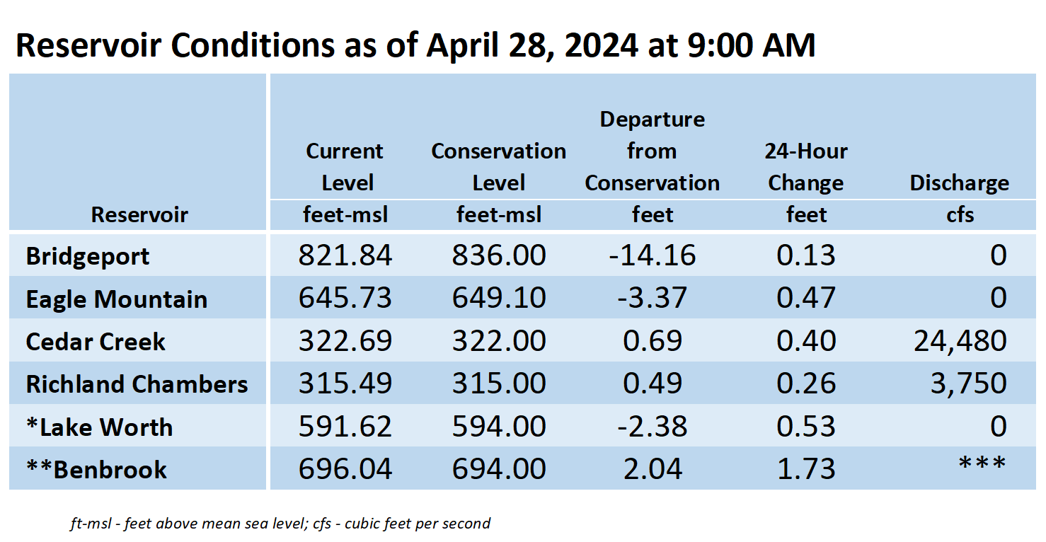
*Lake Worth is owned and operated by the City of Fort Worth. See the City of Fort Worth news feed and NWS forecast page for updates on Lake Worth.
**Benbrook Lake is owned and operated by the U.S. Army Corps of Engineers. ***See Benbrook Lake Home Page for current discharge.
Current lake levels can be found in a variety of locations including TRWD.com, the TRWD watershed data viewer trwd.onerain.com, or download the TRWD Lake Level App for iOS or Android.
Please call the Flood Hotline for further information.
817-720-4296
If prompted to leave a message, the flood monitor on duty will return your message within 30 minutes.
Posted by AL