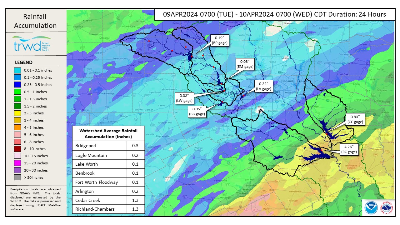
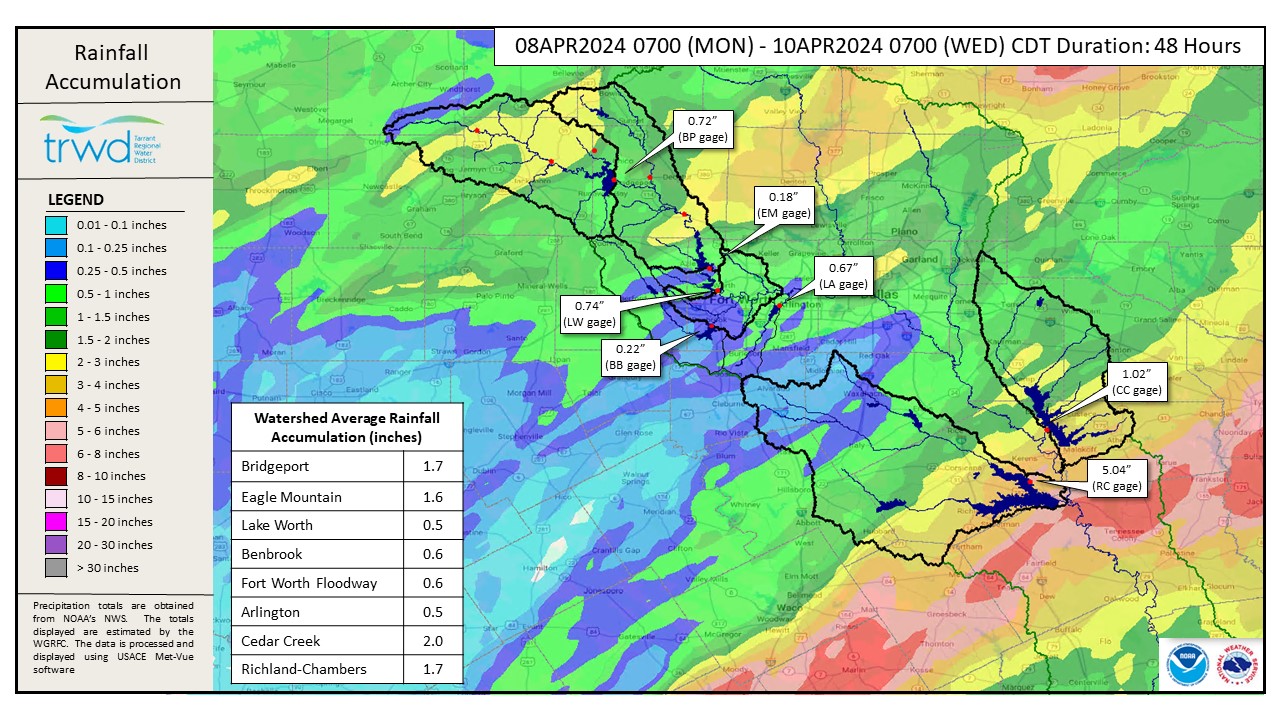
There was heavy rainfall in the Richland-Chambers and Cedar Creek watersheds yesterday, see Graphic 1. Just over four inches of rain was recorded in the six-hour period between 8am and 2pm at Richland-Chambers; this is just shy of a 10-year rainfall event! Graphic 2 shows the total rain over the past two days.
Reservoir Operations
*Projections below are based on conditions up to the time of publication. Additional rainfall and spillway operations past the time of publication are not accounted for in these projections.
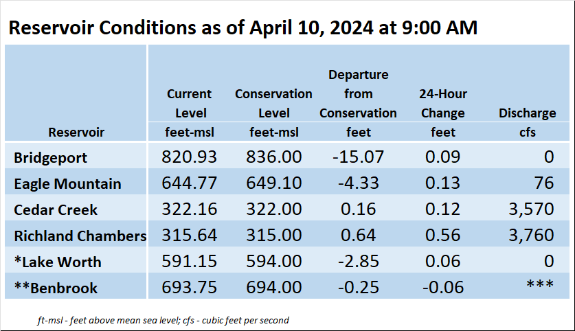
Cedar Creek – Inflows and water levels have peaked. Water levels are not expected to rise unless there is more rain.
Richland-Chambers – Inflows have peaked but water levels are expected to continue a slow rise. An additional one to three inches of rise is possible; additional rainfall would increase the amount of expected rise.
Reservoir staff is monitoring conditions and will make updates to spillway operations as needed to safely pass the excess flood water and return the reservoir back to conservation elevation. Updates regarding spillway gate changes from TRWD lakes will be posted to the Lake Level Blog as they occur.
Outlook
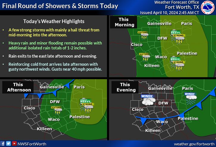
The forecast is calling for more rainfall today. Chances of rain are greater in the Cedar Creek and Richland-Chambers watersheds, see NWS guidance below. Past today the rain is expected to clear out through the weekend. Long term forecasts are showing rain chances to return on Monday.
Follow our partners at the National Weather Service (NWS) and the River Forecast Center (RFC) for the latest information regarding weather and river conditions, respectively.
Current TRWD lake conditions are shown below. Be sure to subscribe to receive e-mail notification of any new Lake Level Blog posts. You can also follow @TRWD_News on X (formerly known as Twitter) to receive Lake Level blog notifications.
Graphic-1. 24-hour Rainfall Totals
Graphic-2. 48-hour Rainfall Totals
Graphic-3. NWS Guidance
*Lake Worth is owned and operated by the City of Fort Worth. See the City of Fort Worth news feed and NWS forecast page for updates on Lake Worth.
**Benbrook Lake is owned and operated by the U.S. Army Corps of Engineers. ***See Benbrook Lake Home Page for current discharge.
Current lake levels can be found in a variety of locations including TRWD.com, the TRWD watershed data viewer trwd.onerain.com, or download the TRWD Lake Level App for iOS or Android.
Please call the Flood Hotline for further information.
817-720-4296
If prompted to leave a message, the flood monitor on duty will return your message within 30 minutes.
Posted by CO