Weather Update
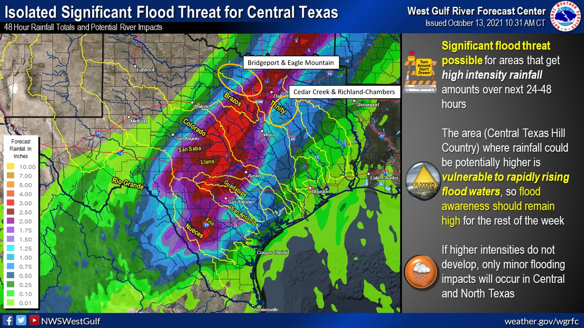
The next 48 hours is expected to be active in terms of rainfall across the State. In the TRWD watersheds 3 to 4 inches of widespread rainfall is likely and isolated areas of heavier rain are not out of the question. Graphice-1, below, from the National Weather Service (NWS) River Forecast Center (RFC) shows the latest thinking on rainfall amounts and the potential for river flooding. The highest potential for river flooding is in Central Texas. Watershed conditions in the TRWD area are such that a bulk of this rain can be absorbed into the ground without turning to runoff. That said, large amounts of rain in a short period of time or rain directly a lake will be converted to runoff at a much higher rate. Also be on the look out for flash flooding in the more urban locations. Please follow our partners at the NWS and RFC for the latest weather and river conditions, respectively.
Reservoir Conditions
Current reservoir conditions are shown below. All reservoirs are currently below conservation level meaning they are less than full. Low level water supply release are on-going at Bridgeport and Eagle Mountain, these will be monitored and adjusted as conditions dictate. Flood operations are not expected at this time; however, staff will continue to monitor conditions and take action as needed to safely move any excess water through the system. Updates to lake status and flood discharges will be posted here as needed.
Remember to check out trwd.onerain.com on your smartphone or computer to view the latest observed lake levels and rainfall totals in the TRWD watersheds.
Please be advised that forecasts and projections are subject to change, and TRWD reservoir operations are based on observed rainfall conditions. Additional updates will be provided as conditions dictate. Be sure to subscribe to receive e-mail notification of any new Lake Level Blog posts. You can also follow @TRWD_News on Twitter to receive Lake Level blog notifications.
Graphic-1. 5-Day Rainfall Forecast

*Lake Worth is owned and operated by the City of Fort Worth. See the City of Fort Worth news feed and NWS forecast page for updates on Lake Worth.
**Benbrook Lake is owned and operated by the U.S. Army Corps of Engineers. ***See Benbrook Lake Home Page for current discharge.
Current lake levels can be found in a variety of locations including TRWD.com, the TRWD watershed data viewer trwd.onerain.com, or download the TRWD Lake Level App for iOS or Android. You may also follow the NWS and the River Forecast Center (RFC) for the latest information regarding weather and river conditions, respectively. You can also check out this YouTube video to see what OneRain is all about!
Please call the Flood Hotline for further information.
817-720-4296
If prompted to leave a message, the flood monitor on duty will return your message within 30 minutes.
Posted by CO.