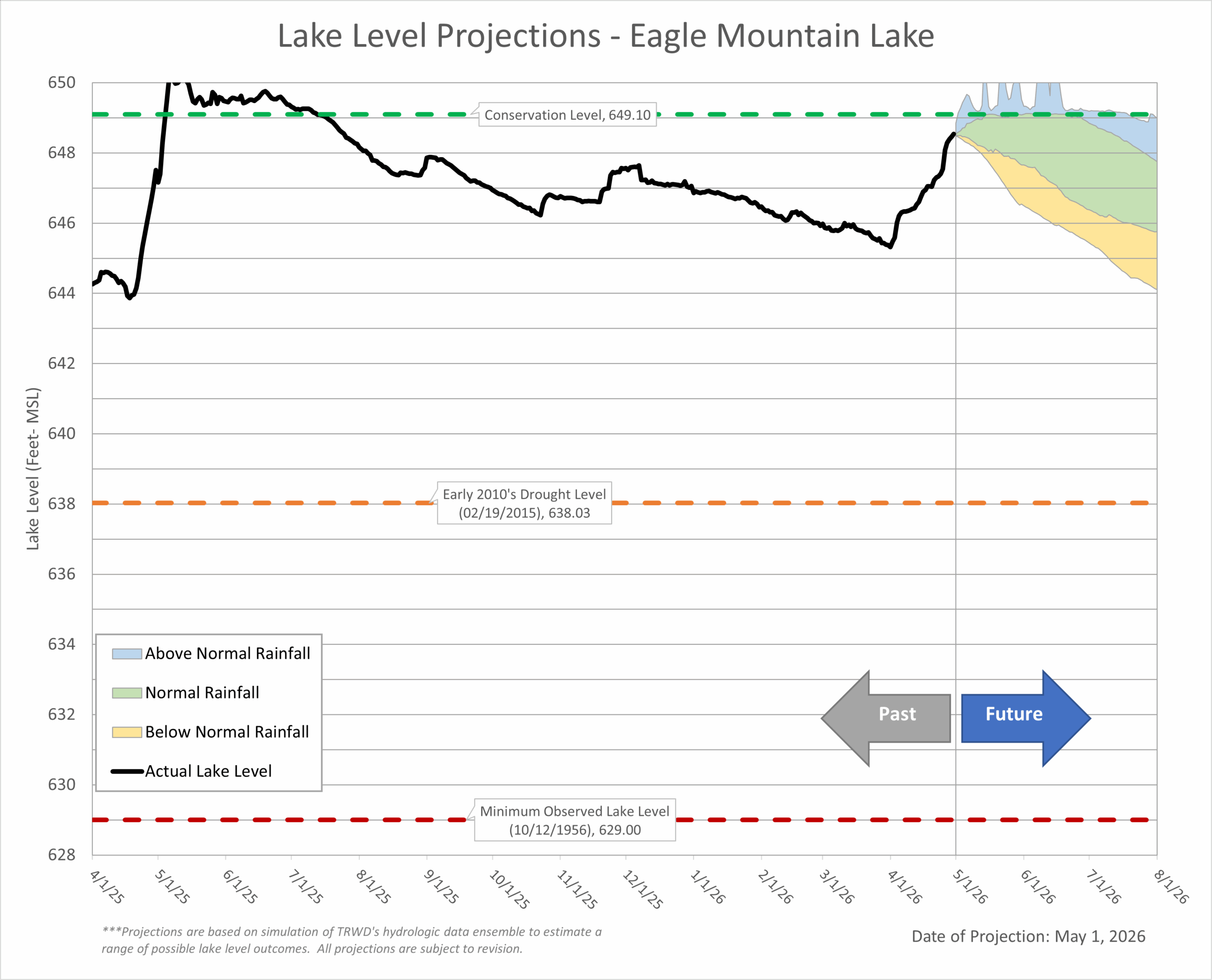
After four months of below normal rainfall, April broke the dry pattern with 5.06” of rainfall recorded at DFW Airport. April rainfall generated inflow to the TRWD lakes, especially at Eagle Mountain Lake, which is currently less than a foot below conservation. TRWD’s system storage is still holding steady at around 89%.
May is typically the region’s wettest month. The latest forecasts point to a wetter than normal first half of the month. If rainfall occurs in the right locations, it could further boost system storage or even push the lakes above conservation, which may trigger flood release operations for TRWD.
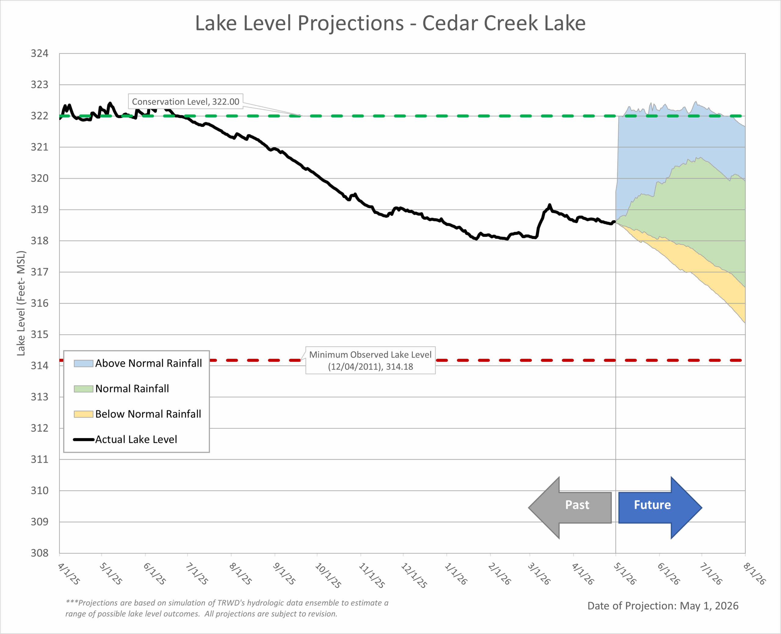
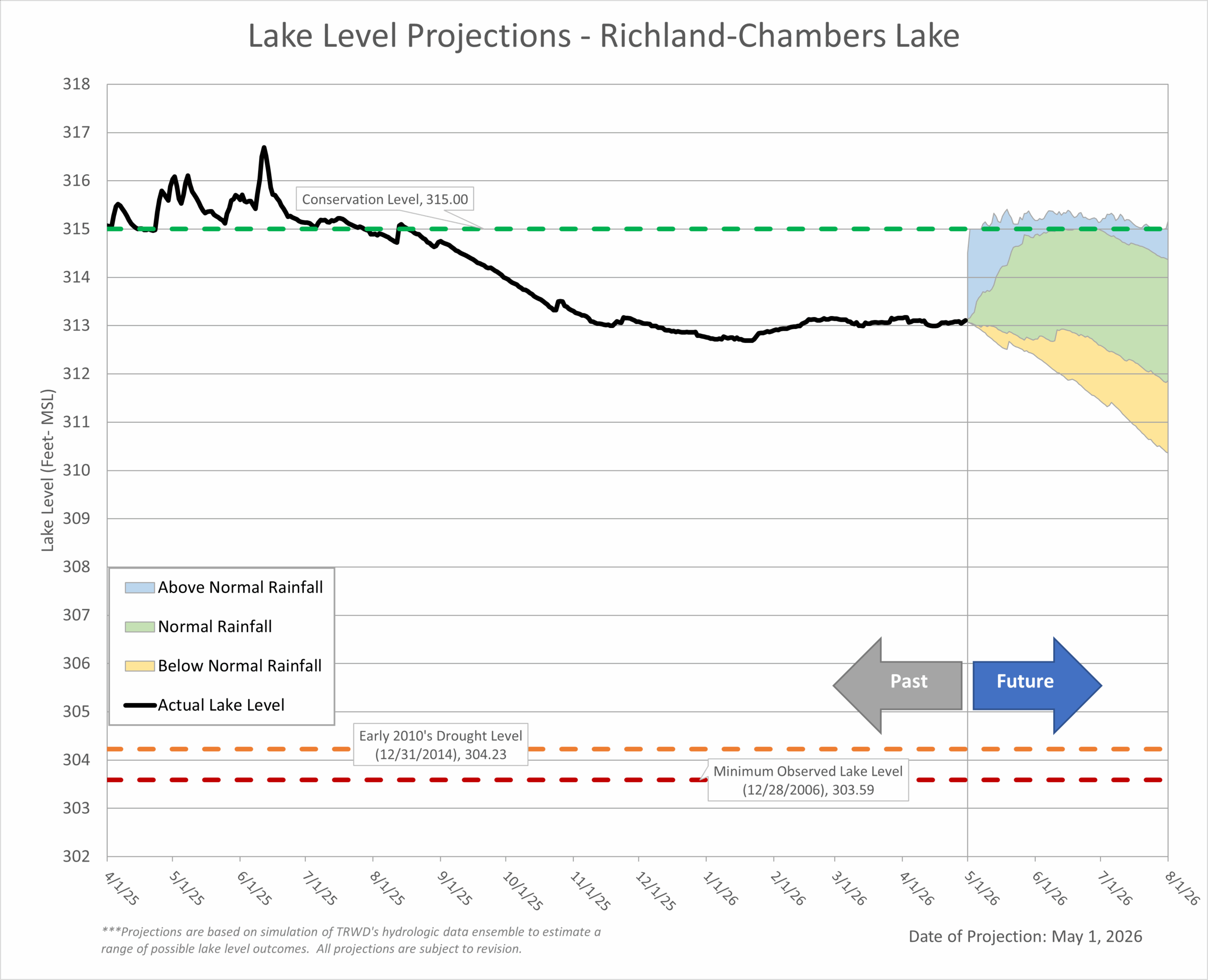
What to Expect: Expect lake levels to follow either the “Normal Rainfall” or “Above Normal” trends (green and blue area on the Lake Level Blog Projection Plots). Actual lake levels will be influenced by the quantity, location, and intensity of this month’s rainfall.
April Highlights:
- Temperature: April was warm, with average temperatures about 5°F higher than normal for DFW (65.6° F).
- Rainfall: With the arrival of spring, all TRWD watersheds recorded above normal precipitation in April, as seen in the rainfall map below.
- Drought Conditions:
- April rainfall improved drought conditions across much of the western part of the region.
- Parts of the southern TRWD service area remain Abnormally Dry (D0) to Moderate Drought (D1).
- Severe Drought (D2) conditions are emerging near TRWD’s East Texas lakes, including Richland‑Chambers and Cedar Creek.
- View the latest conditions on the NWS Drought Monitor.
Looking Ahead:
- La Niña Influence: *ENSO-neutral conditions are officially present.
- Rainfall: Early‑May rainfall may bring some reservoir inflows, while longer‑range outlooks indicate normal conditions through the remainder of spring and into the summer.
- Temperatures: Above-normal temperatures are expected through the spring and into the summer.
- Looking Further: *ENSO-neutral conditions are favored through May-June 2026 (80% chance). In May-July 2026, El Niño is likely to emerge (61% chance) and persist through at least
the end of 2026.
*Note: ENSO, or the El Niño-Southern Oscillation, is a recurring climate pattern that influences global weather. It has two main phases: El Niño, which often brings wetter conditions, and La Niña, which typically leads to drier and warmer weather in Texas, especially during fall and winter. This shift is important for water resource planning, as it can affect rainfall and reservoir levels.
Stay Informed by Checking Out the Following:
- TRWD’s quarterly watershed protection newsletter, The Tributary.
- The latest Lake Level Projections (see below).
- Links to historical lake level plots.
- Past projections compared to actual outcomes.
Thank you for following the Lake Level Blog. Check back next month for more updates!
TRWD Watershed Rainfall
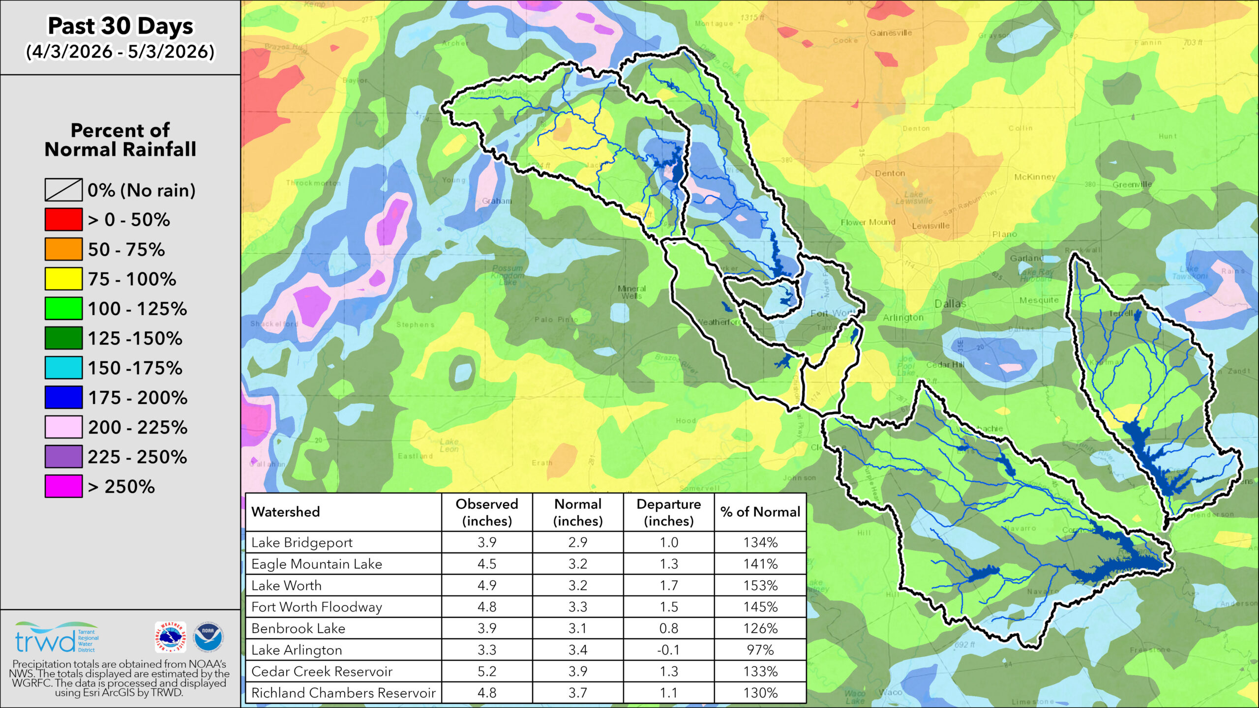
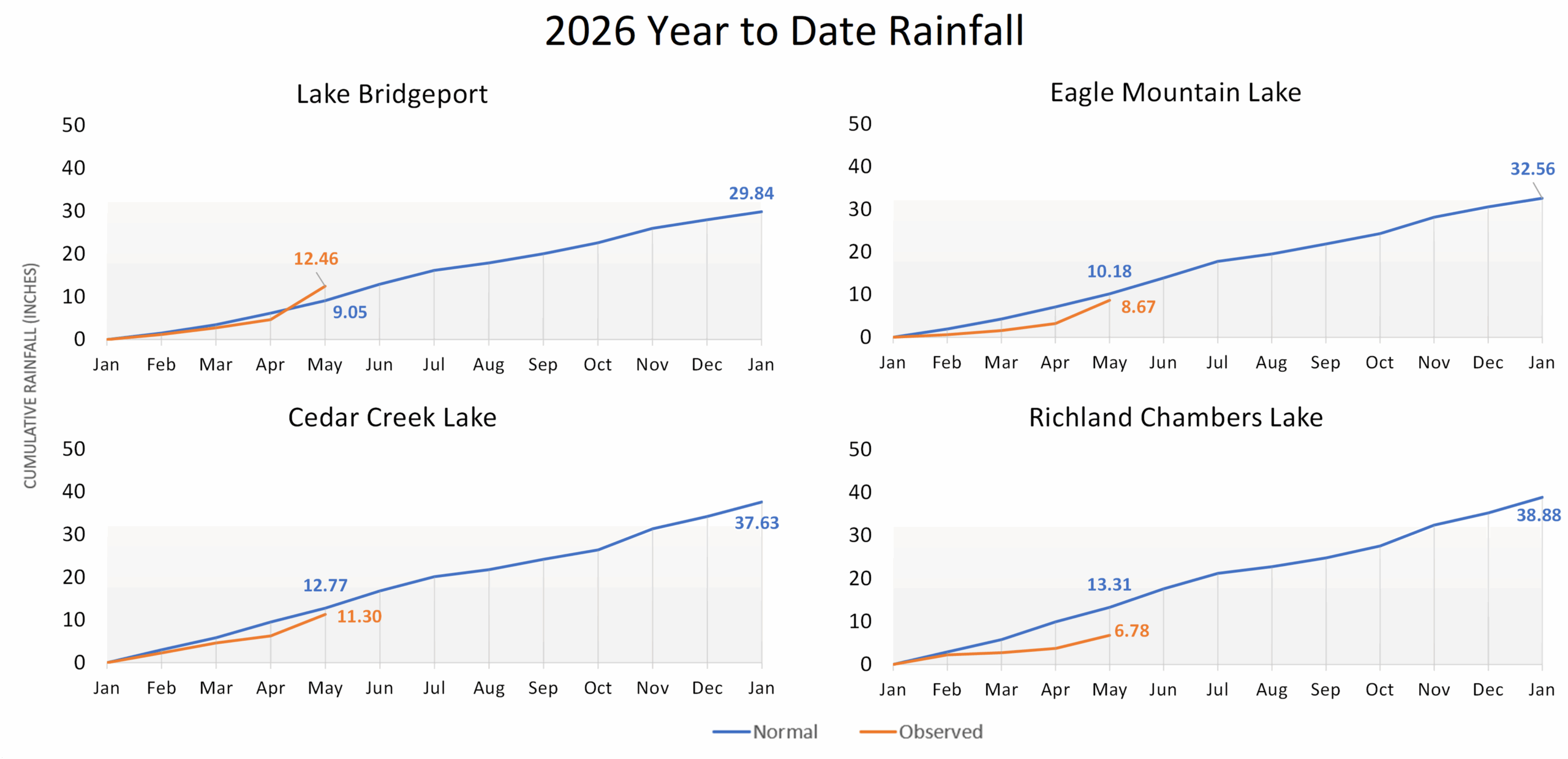
TRWD Lake Rainfall Totals through April 30, 2026
Lake Level Projections
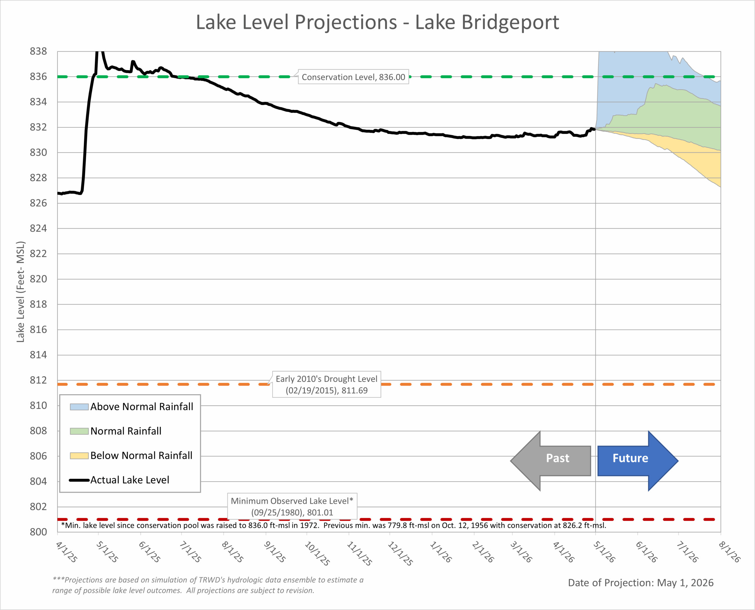 Last Month’s Projection | Historical Lake Levels
 Last Month’s Projections | Historical Lake Levels
 Last Month’s Projection | Historical Lake Levels
 Last Month’s Projection | Historical Lake Levels
Disclaimer: These projections are based on typical operating conditions and expected weather patterns. Actual water use and weather can vary, so observed lake levels may occasionally be slightly higher or lower than the projected range.
Acknowledgments:
- Weather and Climate Insights: Special thanks to Vini de Oliveira and Craig Ottman.
- Reservoir Projections: A big thank you to Vini de Oliveira for his timely reservoir projections.
- Rainfall Analysis: Appreciation goes to Ashley Lowrie for her thorough analysis of observed rainfall.