March 2026 once again repeated the warm and dry pattern from the previous months. The average temperature of 67.5 ° F for March was about 10 degrees higher than the normal (58.2 ° F). Precipitation totals of 2.92″ at the DFW Airport were 0.38″ below the normal (3.30″). Following the same pattern as the previous winter months, TRWD’s system storage is still holding steady at around 88% thanks to localized rainfall in the right areas and lower demands during wintertime.
April is typically a transition month with the onset of spring. Current forecasts indicate April will be warmer than normal, with an increased chance of above‑normal rainfall. If rainfall occurs in the right locations, it could provide a boost to system storage.
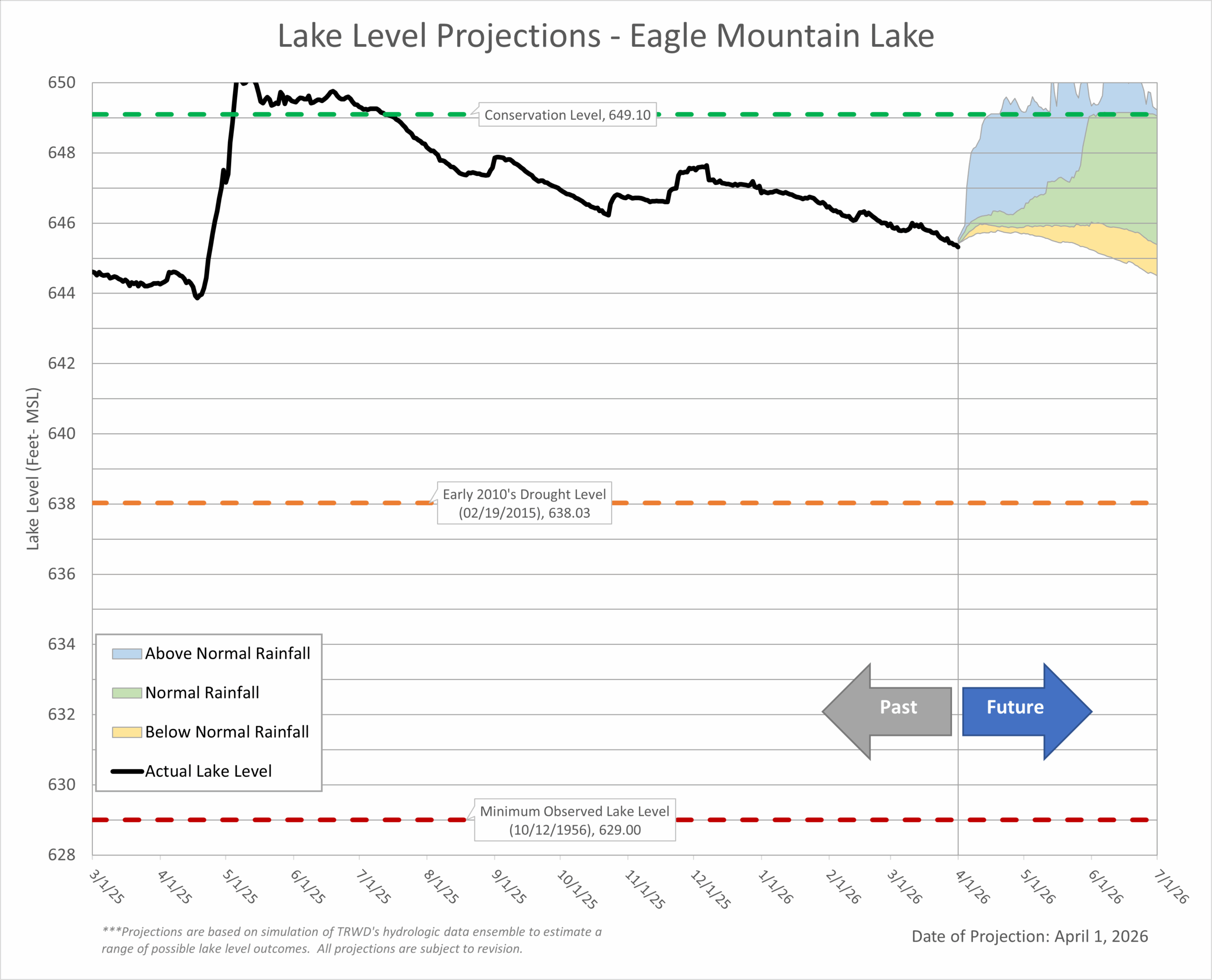
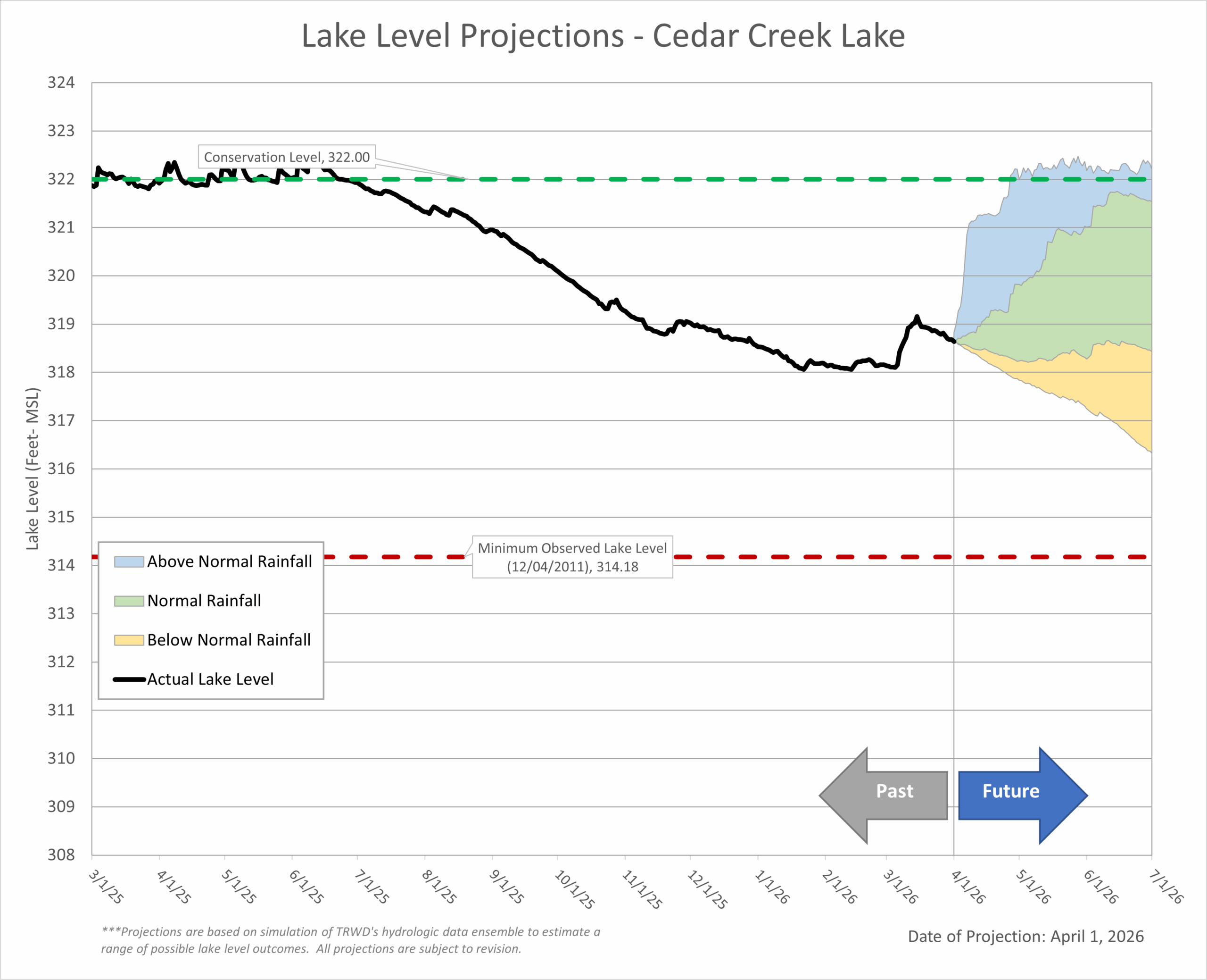
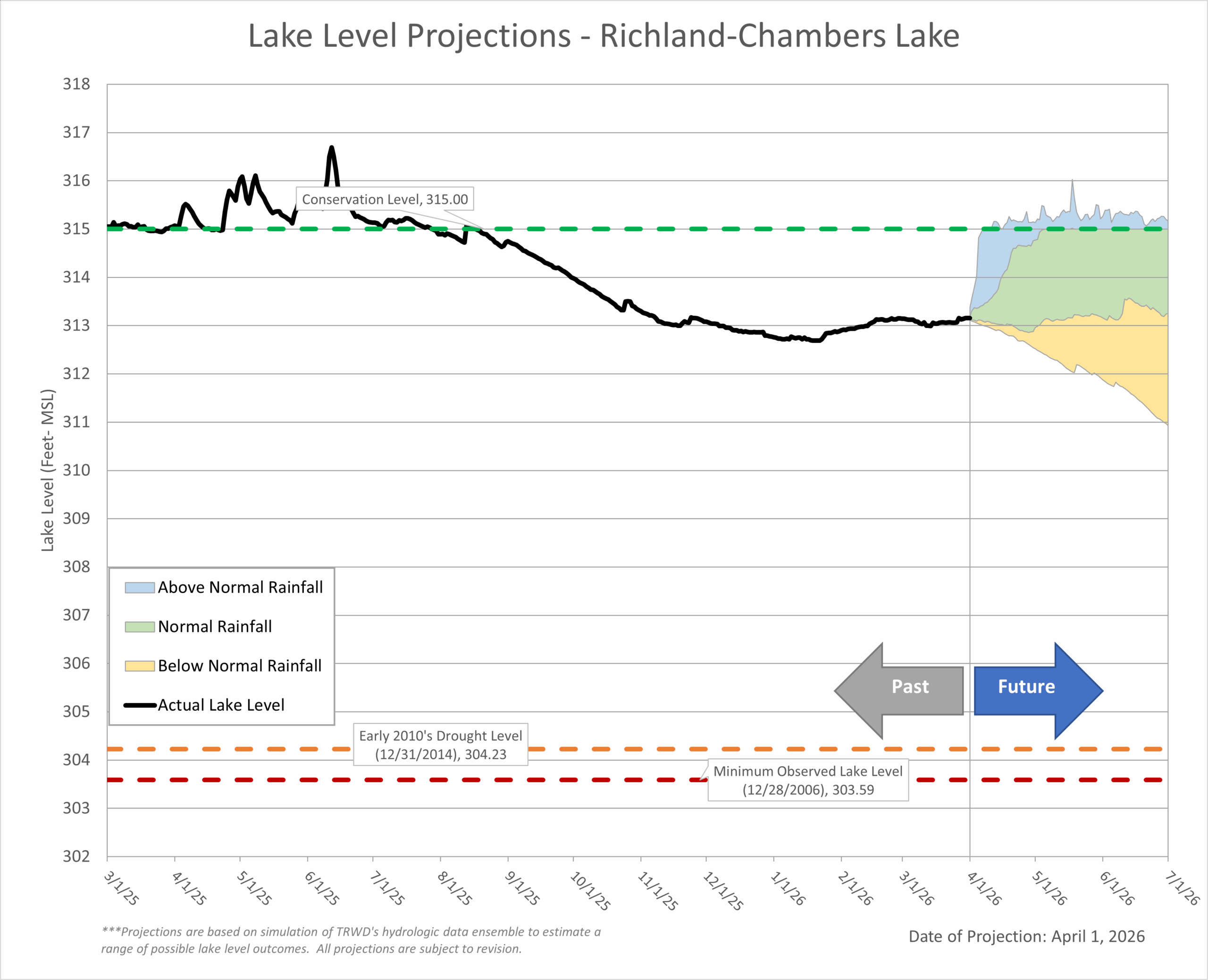
Bottom Line: Expect lake levels to follow the “Normal Rainfall” trend (green area on the Lake Level Blog Projection Plots) or even going into the “Above Normal” trend (blue area on the Lake Level Blog Projection Plots) if the forecast rainfall materializes.
March Highlights:
- Temperature: March was warm, with high temperatures reaching the mid-90s, about 25 degrees higher than normal. The month ended 10 degrees higher than the normal temperature for DFW (58.2° F).
- Rainfall: All TRWD watersheds recorded below normal precipitation in March, as seen in the rainfall map below.
- Drought Conditions: With the lack of rain across the region, most of the TRWD service area remains in the D0 (Abnormally Dry) and D1 (Moderate Drought) categories, as shown in the latest NWS Drought Monitor. This may change if projections materialize, given that April is expected to wetter than normal.
Looking Ahead:
- La Niña Influence: A La Niña condition is still persistent. This typically brings warmer and drier conditions to Texas.
- Rainfall: Early‑April rainfall may generate some reservoir inflows, while longer‑range outlooks indicate generally normal conditions through the remainder of spring.
- Temperatures: Above-normal temperatures are expected through the spring.
- Looking Further: A 55% chance of transitioning from La Niña to ENSO-neutral is expected next month. In June-August 2026, El Niño is likely to emerge (62% chance) and persist through at least the end of 2026.
Note: ENSO, or the El Niño-Southern Oscillation, is a recurring climate pattern that influences global weather. It has two main phases: El Niño, which often brings wetter conditions, and La Niña, which typically leads to drier and warmer weather in Texas, especially during fall and winter. This shift is important for water resource planning, as it can affect rainfall and reservoir levels.
Stay Informed by Checking Out the Following:
- TRWD’s quarterly watershed protection newsletter, The Tributary
- The latest Lake Level Projections (see below).
- Links to historical lake level plots.
- Past projections compared to actual outcomes.
Thank you for following the Lake Level Blog. Check back next month for more updates!
TRWD Watershed Rainfall
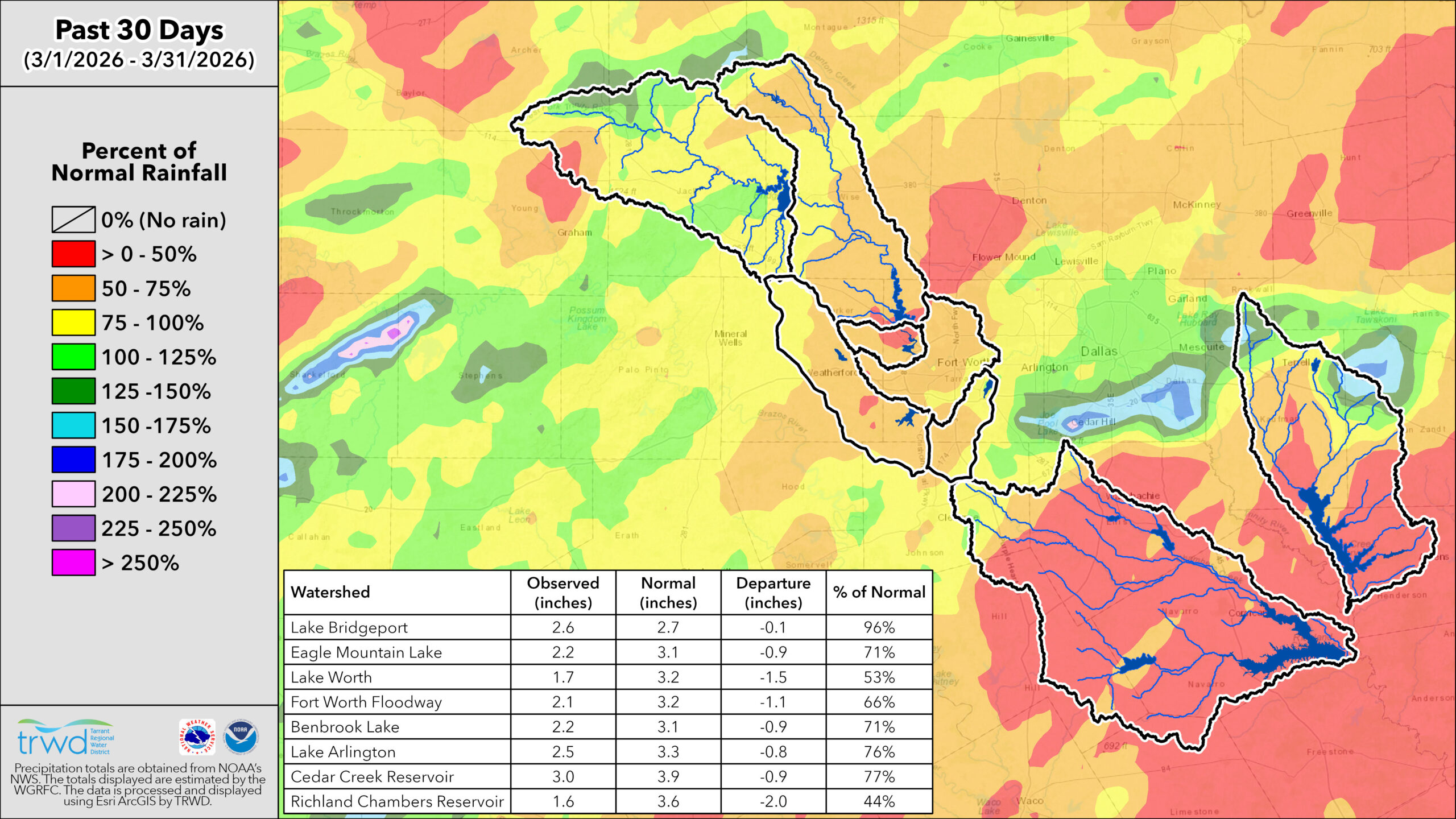
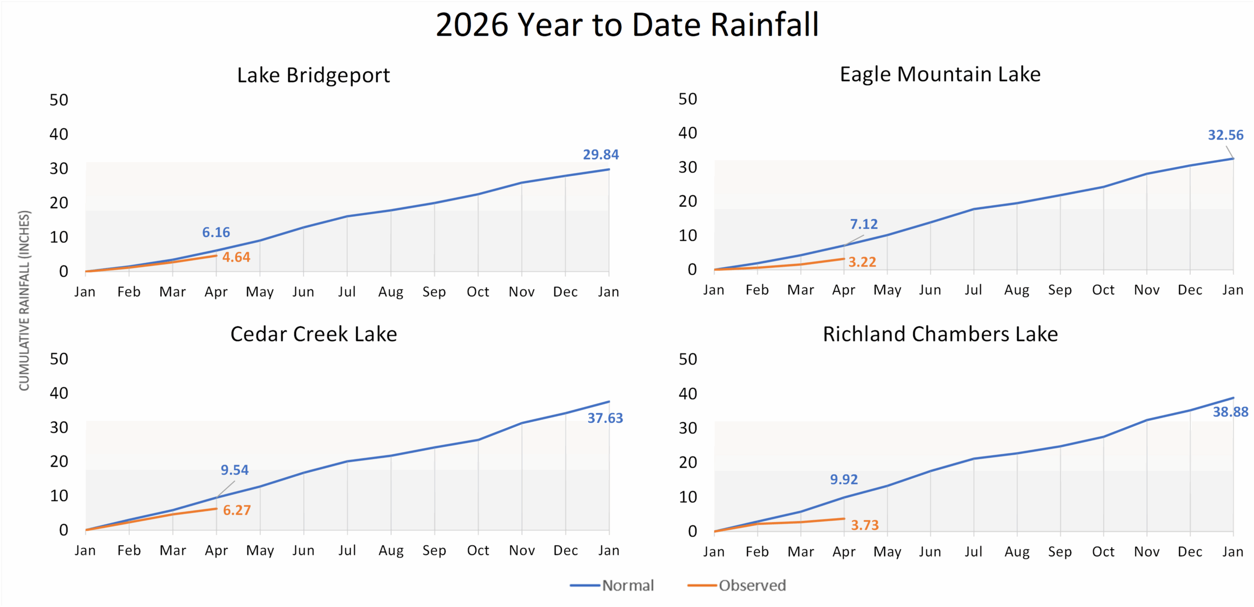
TRWD Lake Rainfall Totals through March 31, 2026
Lake Level Projections
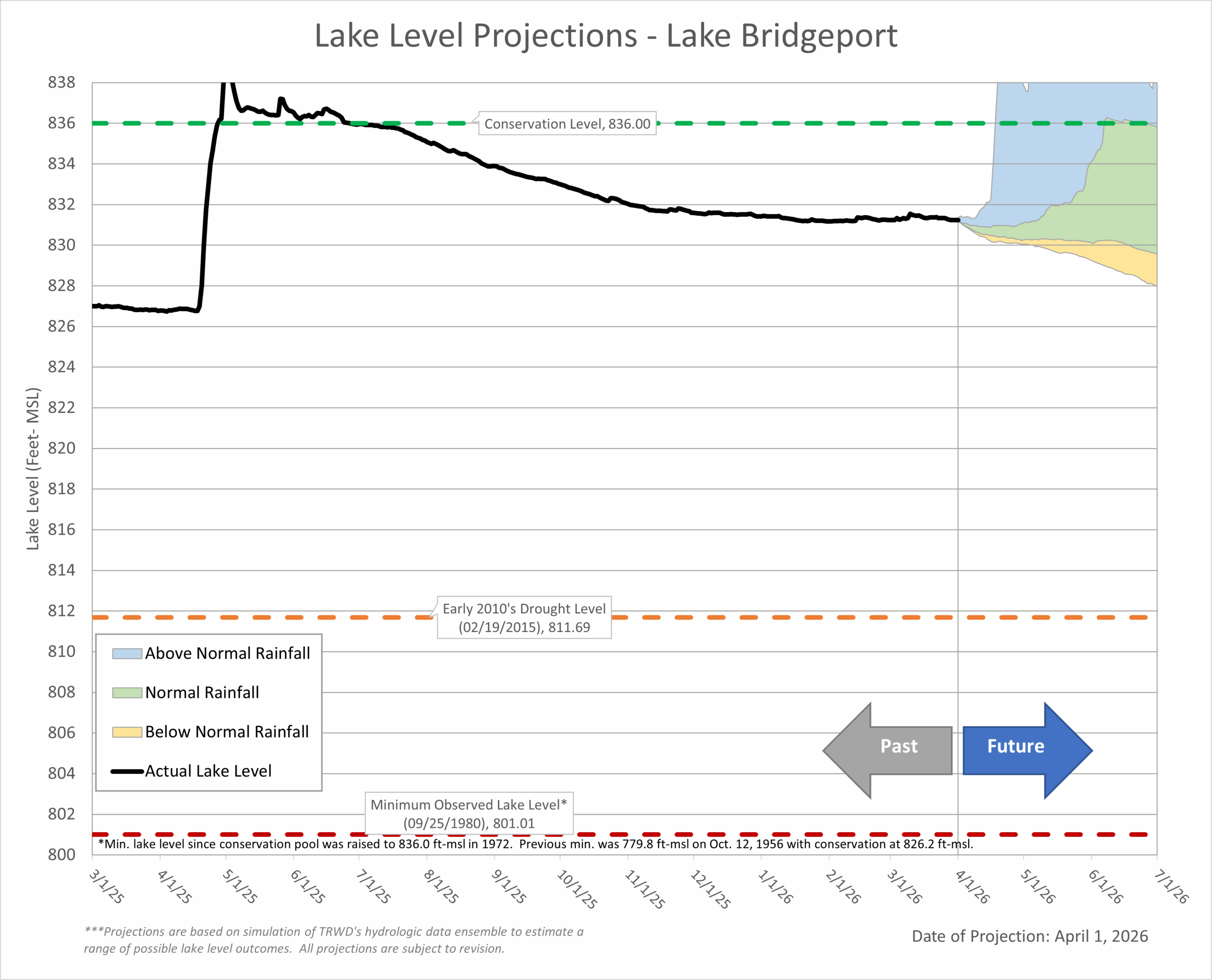 Last Month’s Projection | Historical Lake Levels
 Last Month’s Projections | Historical Lake Levels
 Last Month’s Projection | Historical Lake Levels
 Last Month’s Projection | Historical Lake Levels
Disclaimer: These projections are based on typical operating conditions and expected weather patterns. Actual water use and weather can vary, so observed lake levels may occasionally be slightly higher or lower than the projected range.
Acknowledgments:
- Weather and Climate Insights: Special thanks to Vini de Oliveira and Craig Ottman.
- Reservoir Projections: A big thank you to Vini de Oliveira for his timely reservoir projections.
- Rainfall Analysis: Appreciation goes to Ashley Lowrie for her thorough analysis of observed rainfall.
- Editorial Review: Special thanks to Victoria Cason for her thorough editorial review.