Lake Level Blog

Lake Bridgeport Gage Malfunction

By July 21, 2021

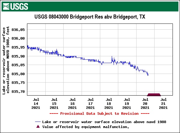
The lake level gage at Lake Bridgeport had an equipment malfunction yesterday around 5 p.m.  It is estimated that the Lake Bridgeport elevation is currently between 835.75 and 835.80.    The United States Geological Survey (USGS) is aware of the issue and is sending a technician out today.    The USGS operates and maintains gages across the entire country.   Lake Bridgeport is one of several sites in the Trinity River watershed funded by TRWD.  To see the full extents of the USGS’s coverage area, check out the National Water Dashboard.

Updates will be posted here once the issue is resolved.


Posted by CO

Lake Current Level Conservation Level* Level Difference**
Arlington 552.00 550.00 2.00
Benbrook 694.91 694.00 0.91
Bridgeport 838.12 836.00 2.12
Cedar Creek 322.28 322.00 0.28
Eagle Mountain 647.52 649.10 -1.58
Lake Worth 592.16 594.00 -1.84
Richland-Chambers 315.87 315.00 0.87

Want to add Lake Levels to your home screen? Click here to learn how

*Conservation Level: The permitted level of water an entity is allowed to hold in a lake. Any amount above the conservation level is used for the temporary storage of flood waters and must be released downstream.

**Difference: Amount above or below conservation level.

Stay connected with TRWD!

Sign up for our newsletter!

Newsletter Sign Up