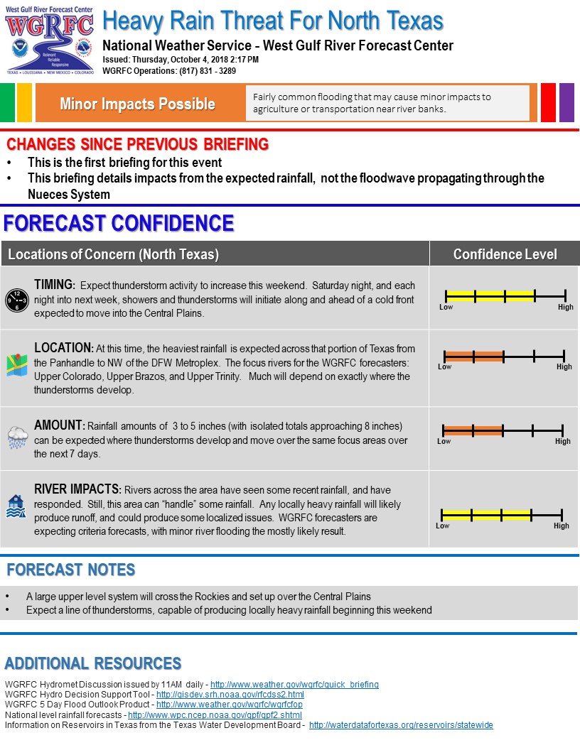
The National Weather Service (NWS) is forecasting rainfall over the next six days in the TRWD reservoir watersheds. The NWS River Forecast Center‘s latest briefing is calling for a possibility of minor river flooding in the upper Trinity River basin, see below. Over the weekend, rainfall is expected to be scattered in nature and not expected to have a major impact on TRWD reservoirs. Heaviest rainfall totals are expected Monday afternoon into Tuesday. The latest forecasts are predicting 2-3 inches of rain in the Eagle Mountain and Bridgeport watersheds early next week. This rainfall has more potential to impact TRWD reservoirs than the weekend rainfall. Current conditions at TRWD reservoirs are shown below. At the moment TRWD monitoring staff is not expecting TRWD reservoirs to fill, however the possibility cannot be ruled out. TRWD staff will be monitoring conditions 24 hours a day. Please be advised that forecasts are subject to change and TRWD reservoir operations are based on observed rainfall conditions. Additional updates will be provided here if conditions dictate, please check back.
River Forecast Center Guidance

The latest update of reservoir conditions follows:
Lake Bridgeport
- Current reservoir elevation – 829.85 ft-msl.
- Conservation level elevation – 836.00 ft-msl.
- Current discharge is 0 cfs.
Eagle Mountain Lake
- Current reservoir elevation – 647.89 ft-msl.
- Conservation level elevation – 649.10 ft-msl.
- Current release is 144 cfs.
Lake Worth (owned and operated by the City of Fort Worth)
- Current reservoir elevation – 592.17 ft-msl.
- Conservation level elevation – 594.00 ft-msl.
- Current discharge is 0 cfs.
- See City of Fort Worth news feed for updates on lake
Cedar Creek
- Current reservoir elevation – 320.11 ft-msl.
- Conservation level elevation – 322.00 ft-msl.
- Current discharge is 0 cfs.
Richland-Chambers
- Current reservoir elevation – 313.39 ft-msl.
- Conservation level elevation – 315.00 ft-msl.
- Current discharge is 0 cfs
Please call the Flood Hotline for further information.
817-720-4296.
If prompted to leave a message, the flood monitor on duty will return your call within 30 minutes.
*ft-msl – feet above mean sea level; cfs – cubic feet per second
Post based on conditions as of October 5, 2018, at 11:00 AM