Bottom Line
Rainfall Threat Continues, But It Is Winding Down.
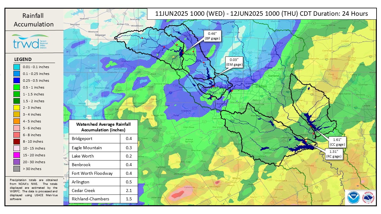
TRWD lakes are actively responding to additional precipitation. Over the past day, TRWD East Texas lakes received significant additional rain, with Cedar Creek and Richland-Chambers watershed getting 2 and 1.5 inches of rain, respectively (Graphic 1). These lakes are actively reacting to inflows from this past rain event.
All four TRWD lakes—Bridgeport, Eagle Mountain, Cedar Creek, and Richland-Chambers—are currently spilling. Our teams are closely monitoring inflows and managing releases to balance water supply needs and flood mitigation.
Projections
- Bridgeport: Yesterday’s event caused a small rise in the lake due to local inflows. A low-level release continues, and no additional significant rise in lake level is expected at this time.
- Eagle Mountain: Low-level discharges are ongoing. Lake levels are expected to remain steady with no additional rainfall.
- Cedar Creek: Following a sharp increase due to inflows from yesterday’s rain, the lake is now gradually decreasing. Discharges will continue to be adjusted as needed.
- Richland-Chambers: Water levels are rising as upstream inflows from Richland and Chambers Creeks reach the lake. The leak is expected to peak in the next 12 to 24 hours. Discharges were increased at 11 pm and will continue to be adjusted accordingly to manage the increase.
*Projections are subject to change and are based on past precipitation.
Looking Forward
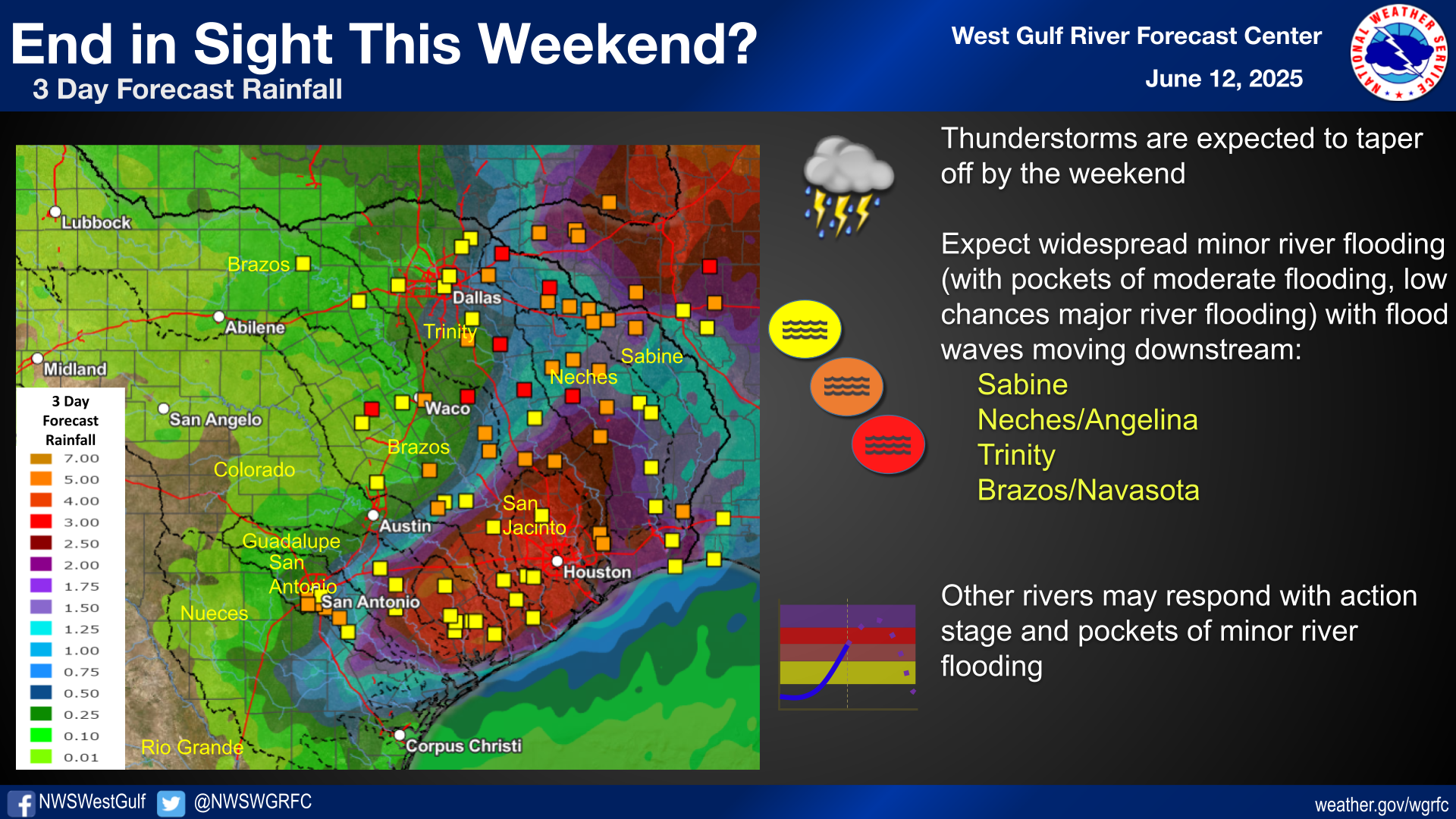
While thunderstorms and locally heavy rainfall are still expected in some areas, there is an end in sight to the focused heavy rainfall threat. The focus for renewed heavy rainfall has shifted to the Upper and Middle Texas coast. However, rain chances linger over the TRWD system through the weekend. See Graphic 2 for guidance from the River Forecast Center.
Next Update: The next update will be tomorrow. TRWD staff will continue to monitor conditions 24/7 and are available to answer the flood line if there are any questions or concerns.
Graphic 1) Observed Rainfall
Graphic 2) River Forecast Center Guidance
Current Lake Conditions
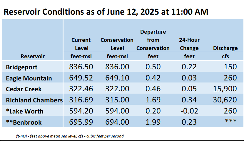
The information shown in the table above can also be found at trwd.onerain.com.
*Lake Worth is owned and operated by the City of Fort Worth. Please contact the City of Fort Worth and NWS forecast page for updates on Lake Worth.
**Benbrook Lake is owned and operated by the U.S. Army Corps of Engineers.
***See Benbrook Lake Home Page for current discharge.
Additional Information
TRWD staff will continue to monitor conditions and adjust flood discharges accordingly. Updates on reservoir conditions will be posted, and subscribers will receive email notifications of new blog posts. Also, visit our partners at the (NWS) and the River Forecast Center (RFC) for the latest information regarding weather and river conditions.
Contact Information
For questions, call the Flood Hotline at 817-720-4296 to leave a message for a TRWD Flood Team member.
Posted by VdO.