Bottom Line
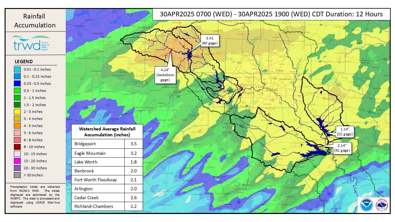
There was significant rainfall across the TRWD watersheds. Most notably in the area directly above Lake Bridgeport which received rainfall depths in the 4-to-5-inch range. TRWD staff is actively assessing the reservoir inflows and spillway operations to manage the excess runoff. The Bridgeport and Eagle Mountain flood discharges were increased this evening, see current conditions below.
Projections
While it is still early and there are many variables in play, the following are the latest projections based on what we know right now.
- Bridgeport: We currently have confidence the lake level will not rise above elevation 840 ft-msl without additional rainfall. Elevation 839 ft-msl by tomorrow evening cannot be ruled out at this time.
- Eagle Mountain: Flood discharges were initiated today to begin moving water in advance of inflows that will be coming from the Bridgeport discharges. Even with these discharges, the lake is expected to reach 649.1 this weekend.
- Cedar Creek: The lake level is above conservation and spillway discharges have been initiated to manage the excess runoff.
- Richland-Chambers: The lake level remains above conservation level and spillway operations are on-going.
*Projections are subject to change and are based on past precipitation.
Looking Forward
TRWD staff is watching the radar for additional rainfall overnight. There is a chance of rain tomorrow evening with depths in the 0.5 to 1-inch range, see Graphic 2 for NWS Guidance.
Next Update: The next update will be tomorrow morning. TRWD has staff monitoring conditions 24/7 and available to answer the flood line if there are any questions or concerns.
Graphic 1) Today’s Rainfall
Graphic 2) NWS Guidance
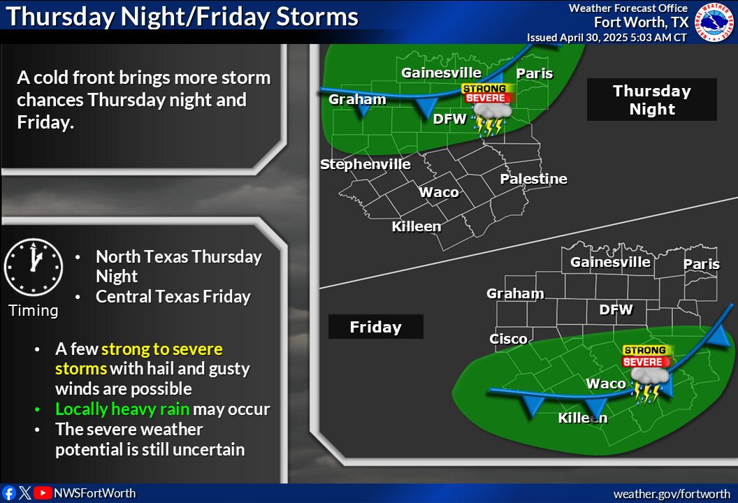
A weather front is expected to move south across the region from late Thursday into Friday, leading to scattered showers and storms. Some of these storms may be severe, with large hail and damaging winds. The risk of flooding will increase due to periodic heavy rain, particularly in areas that have already experienced flooding or heavy rainfall.
Current TRWD Lake Conditions
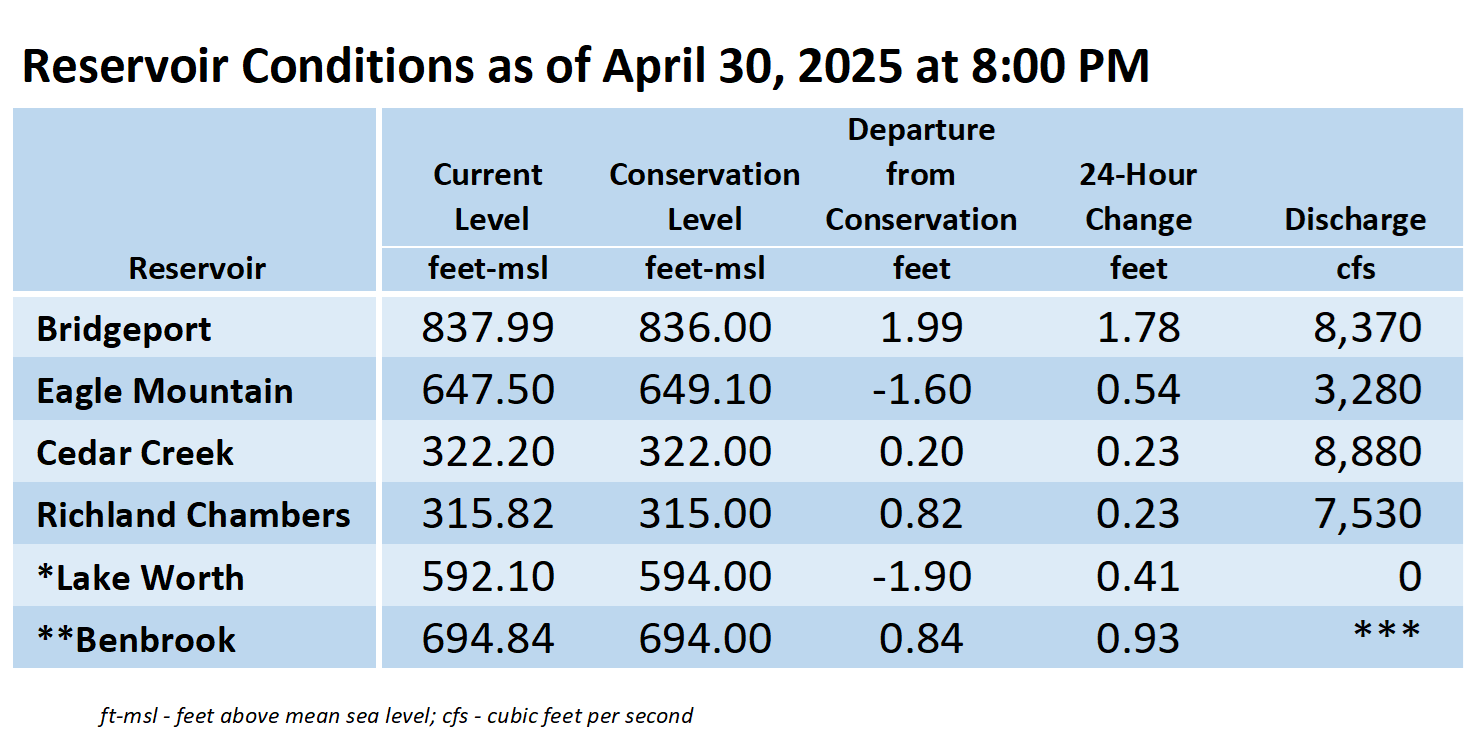
The information shown in the table above can also be found at trwd.onerain.com.
*Lake Worth is owned and operated by the City of Fort Worth. See the City of Fort Worth news feed and NWS forecast page for updates on Lake Worth.
**Benbrook Lake is owned and operated by the U.S. Army Corps of Engineers. ***See Benbrook Lake Home Page for current discharge.
Additional Information
TRWD staff will continue to monitor conditions and adjust flood discharges accordingly. Updates on reservoir conditions will be posted, and subscribers will receive email notifications of new blog posts. Also, visit our partners at the (NWS) and the River Forecast Center (RFC) for the latest information regarding weather and river conditions.
Contact Information
For questions, call the Flood Hotline at 817-720-4296 to leave a message for a TRWD Flood Team member.
Posted by CO.