Our thoughts are with those affected by the recent flooding in central Texas. This story, about successful flood management efforts earlier this year, highlights the important work of water engineers in protecting communities.
When heavy rain started falling about 100 miles northwest of Fort Worth in mid-April, Tarrant Regional Water District engineers were already hard at work, taking steps to protect the Fort Worth area from flooding.
Working around the clock, the team monitored gauges and sensors from as far away as Bowie and Olney. They consulted meteorologists and crunched data in complex computer models to control the flow of water from area streams and reservoirs, in an effort to keep homes and roads from flooding.
Over the next 45 days, as rainfall filled reservoirs, creeks, and rivers, the District’s flood team of hydrologists, engineers and data scientists continually did a delicate dance with Mother Nature.
“The flood was kind to us because the intense rainfall hit high up in the watershed and we had time to pass that water through and manage it,” said Zach Huff, TRWD’s Water Resources Engineering Director. “That’s not always the case.”
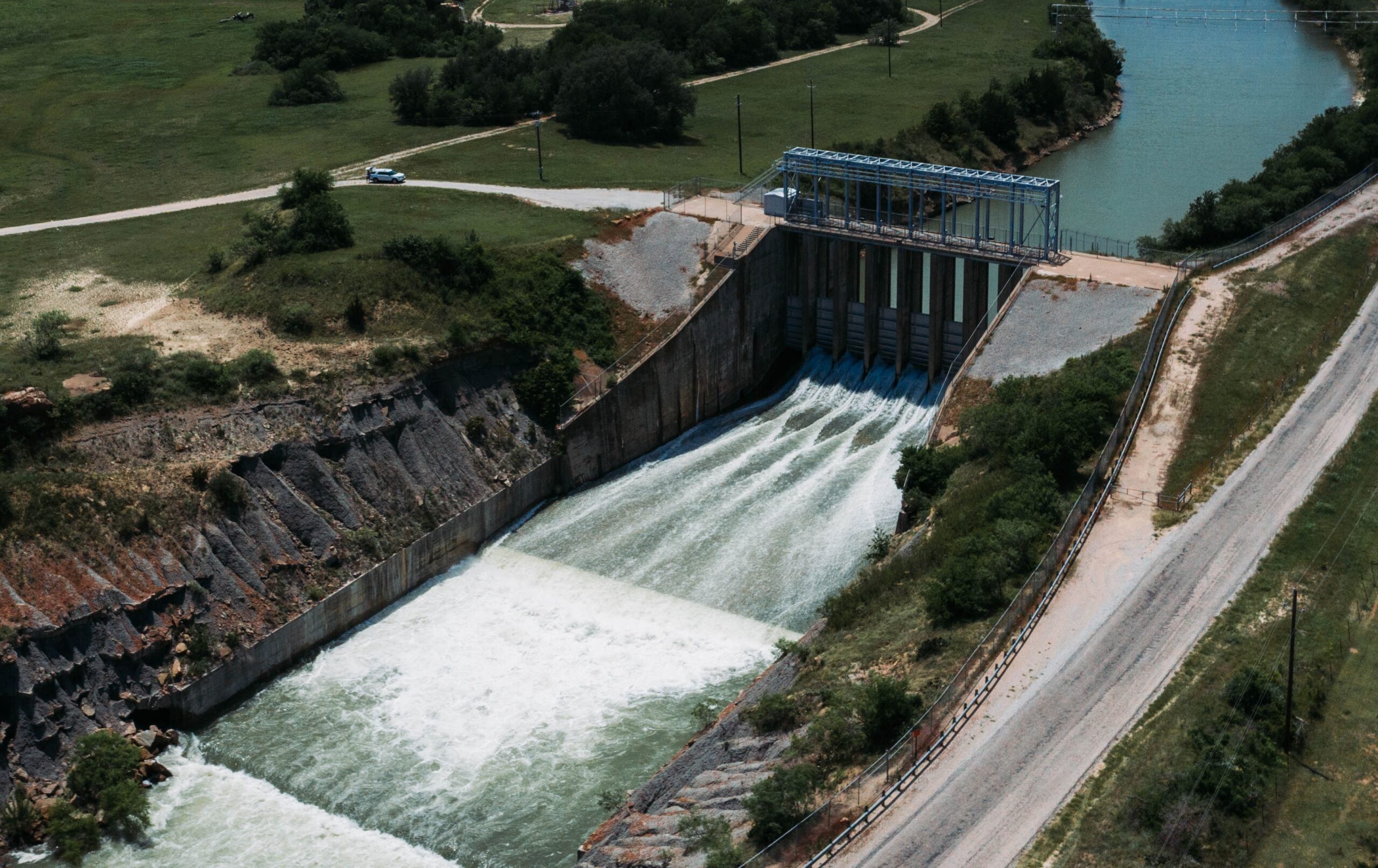
The District created its flood control team to handle these types of situations. Working out of TRWD’s Fort Worth headquarters, the team monitors information from the field, more than 80 river and stream gauges, and the National Weather Service River Forecasting Center.
The team’s first priority is public safety. In addition to protecting the integrity of the system’s dams, they try to keep roads used by emergency management personnel clear and lessen property damage downstream of the reservoirs.
During the recent storms – ranked in the Top Ten weather events to hit in the West Fork of the Trinity River system – 18.3 inches of rain fell in the Lake Bridgeport watershed from April 14 to May 29.
In the Eagle Mountain watershed, 15.3 inches of rainfall fell; near Lake Worth, 9.4 inches; the Fort Worth floodway 9.2 inches; and Lake Benbrook 9.8 inches.
Keeping all that water under control often meant taking steps that may have seemed counterintuitive to a public unaware of what was happening further north in the Trinity River watershed.
The goal was to release the water from reservoirs – from Lake Bridgeport to Eagle Mountain Lake to Lake Worth – at a lower rate for a longer duration of time, Huff said
“It will rain hard 40 to 50 miles away, and it will drizzle at Lake Worth and Eagle Mountain Lake,” Huff said. “People will wake up and say, ‘It (the storm) barely got my lawn wet, and you’re releasing all this water! What is going on?’”
“People will get frustrated by what they see, but they don’t see all the water in the basin 50 miles away,” he said.
While multiple small roads between Lake Bridgeport and Eagle Mountain Lake were swamped by local flooding, the District was able to keep State Highway 114 and State Highway 380 near Runaway Bay open by slowly releasing the water from the reservoirs.
Water did get within inches of a house near Bridgeport, but, in the end, no homes were flooded during the heavy rains.
“So, it’s a combination. If you release a lot of water, the flooding can occur downstream, and if you hold it back, flooding can occur upstream,” Huff said. “So, depending on where the rain hits, you are making those decisions.”
The other good news from the rainfall over the last few months is that, as the District prepares to enter the dry summer months, the West Fork of TRWD’s storage system is at 102 percent.
The amount of rain that fell in the Lake Bridgeport watershed was equal to the volume of water stored in the Richland Chambers Reservoir.
The flood water discharged from the West Fork part of the TRWD system was equal to the total volume of Eagle Mountain Lake.
Those record-setting rainfalls also contributed to the TRWD’s system being full for the first time since 2021.
As the rain continued to fall in May and early June, Huff’s flood team remained vigilant, but it toggled back and forth between 8-, 12-, and 24-hour shifts.
“Flood management is like water supply management. People don’t think about it unless there’s a problem,” Huff said.