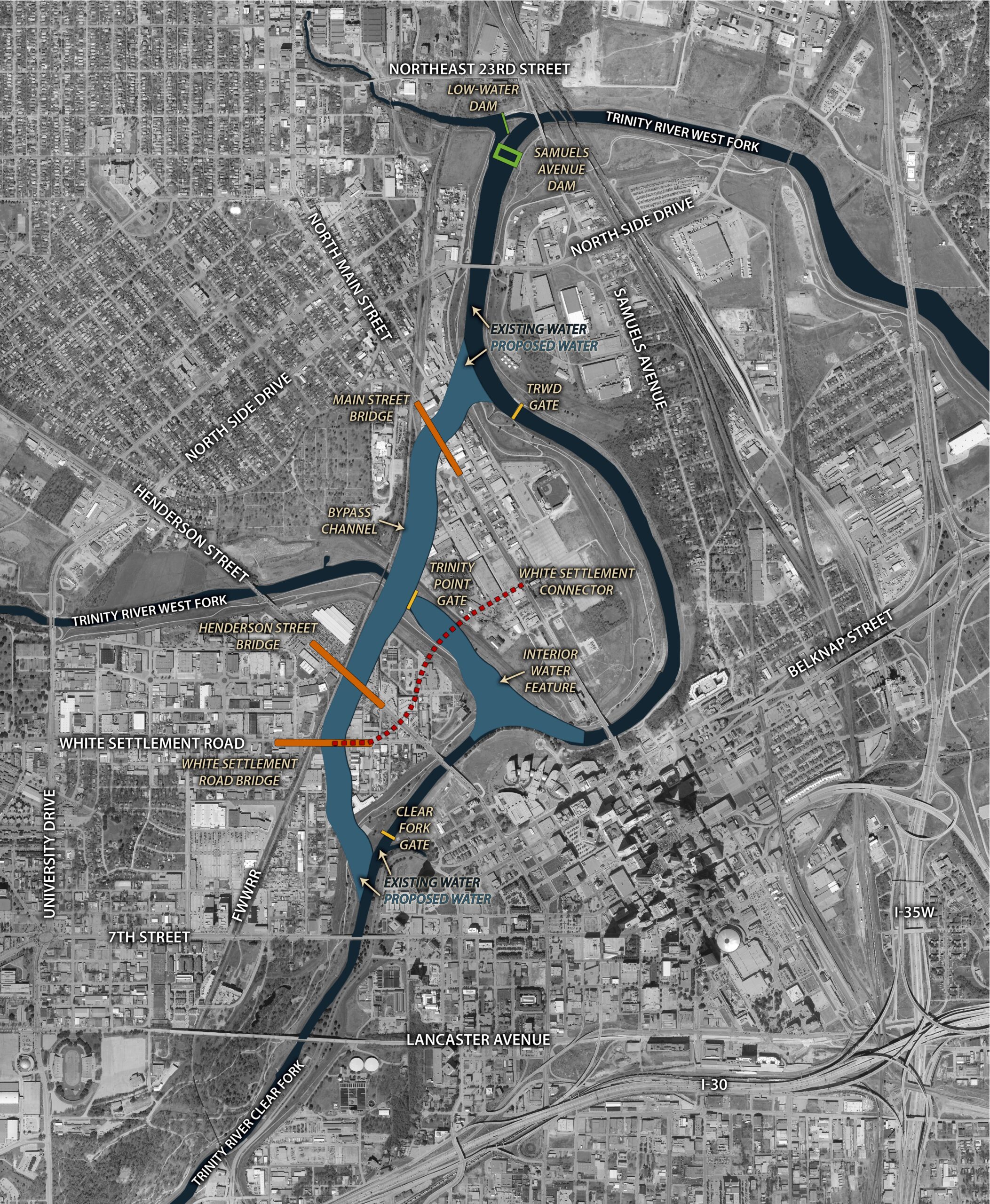
Today, the U.S. Army Corps of Engineers, Fort Worth District, awarded an architect-engineer contract to Black and Veatch-GEI Joint Venture, totaling $4.5 million, to update the conceptual designs and perform the necessary physical and hydraulic modeling for three flood gates and one pump station in support of the Modified Central City Project. The flood gates will be closed during large system events to divert flood waters through the bypass channel.
Funds provided in the Fiscal Year 2023 Workplan from the Disaster Relief Supplemental Appropriations Act of 2022 are being used to progress the design of these features, to include a planned follow-on action to finalize the designs. These funds are part of the $423 million of total Federal funding the project has received over the last two years. The designs of the Trinity Point, Clear Fork, and TRWD Flood Gates and TRWD Pump Station add to the additional ongoing designs of the North Bypass Channel, South Bypass Channel, Rockwood Park Valley Storage, University Drive Valley Storage, and Oxbow Site E Valley Storage which are required to meet the critical path of the project.
The U.S. Army Corps of Engineers Program Manager, Kalli Egan, stated “The award of this contract meets another commitment made to progress the Modified Central City Project. Moving the designs of the gates and pump station forward will provide the integration needed for all operational aspects of the Bypass Channel to reduce flood risk to upstream Fort Worth neighborhoods.”
The Fort Worth Floodway levees were originally constructed by local community interests in response to flooding events in the early 1900s. This system was modified in the 1950’s and incorporated as a congressionally authorized project. The Fort Worth Floodway is a federally authorized and non-federally operated and maintained, urban flood risk management system. The current system, as we know it today, was constructed in the 1960s. As a result of congressionally authorized floodway studies, it was determined that modifications (as defined by the Modified Central City Project) are required to reduce flood risk.
The project is in Fort Worth, Texas. The Modified Central City Project has various components including an approximate 8,400-foot bypass channel, three flood gates, one pump station, two dams (Samuels Avenue and Marine Creek), and valley storage mitigation sites (Gateway Park, Ham Branch, Riverside Park, Rockwood Park West, Samuels Avenue, and University Drive) to provide flood risk management functions along the Clear Fork and West Fork of the Trinity River.
Additional Trinity River Vision/Central City Project information is available at https://www.swf.usace.army.mil/Missions/Civil-Works/Trinity-River-Central-City/ and https://trwd.com/central city/.
Visit the Fort Worth District Web site at: www.swf.usace.army.mil and social media at: https://about.me/usacefortworth.