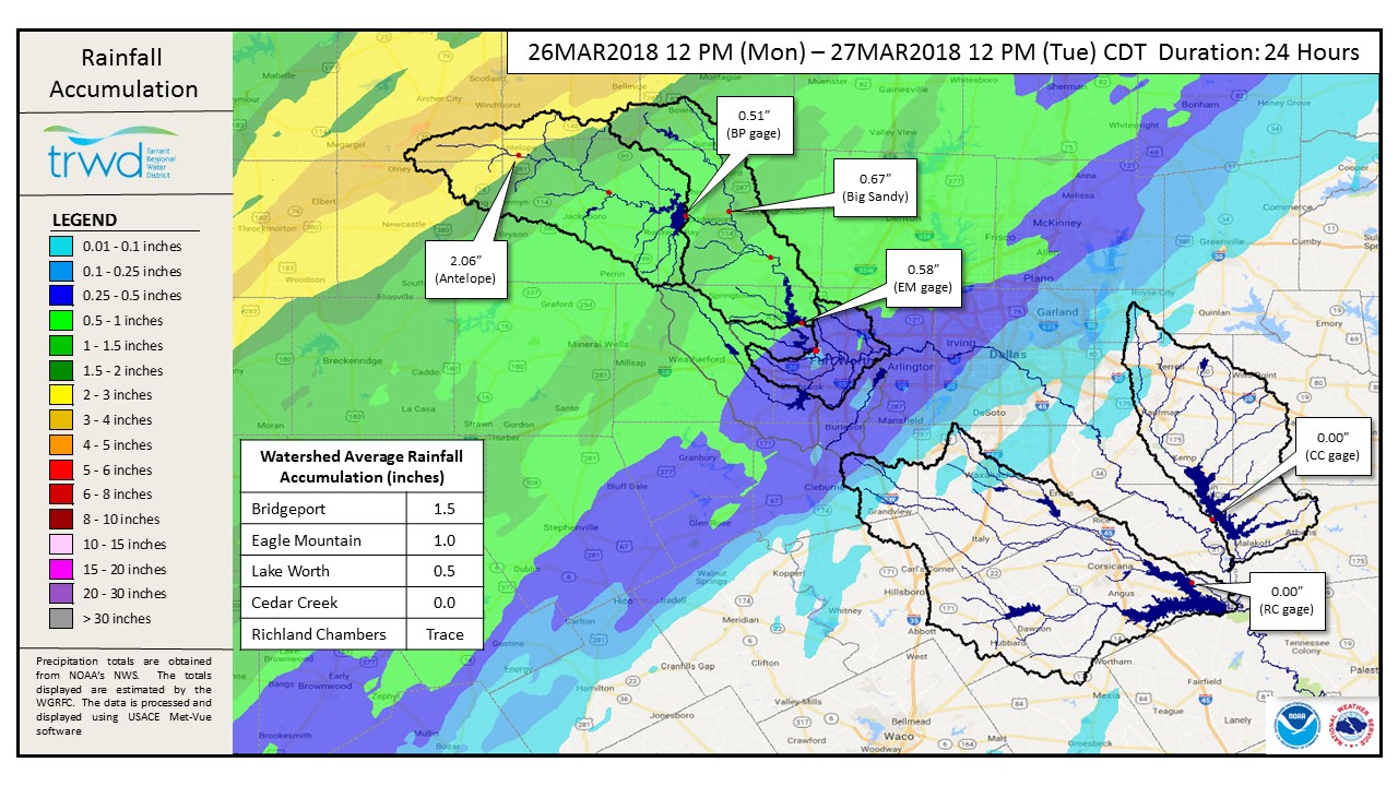
TRWD staff continues to monitor conditions in the District reservoir watersheds 24 hours a day. The past 24 hours have brought a varying amount of rainfall across the Lake Bridgeport and Eagle Mountain Lake watersheds. A map displaying the radar-estimated rainfall depths along with rain gauge observations for the District area of interest is displayed below. The greatest rainfall totals have been in the headwaters of the Lake Bridgeport watershed near Antelope. This water will not make it to Lake Bridgeport for 2-4 days if it makes it at all due to infiltration and channel losses. Elsewhere, there has been about an inch of rainfall. This has not been enough to generate significant runoff at this time, but this could change and District staff will be watching the stream gauges closely over the next few days. The eastern reservoirs have received little to no rain so far, but this is expected to change this afternoon through tomorrow afternoon according National Weather Service guidance. Please check back during this event for further updates.
The latest update of reservoir conditions follows:
Lake Bridgeport
- Current reservoir elevation – 835.21 ft-msl.
- Conservation level elevation – 836.00 ft-msl.
- The first habitable structure is at 839.02 ft-msl, Highway 380 at Runaway Bay is 838.97 ft-msl.
- Current discharge is 0 cfs.
- The reservoir is open.
Eagle Mountain Lake
- Current reservoir elevation – 649.44 ft-msl.
- Conservation level elevation – 649.10 ft-msl.
- The first habitable structure (enclosed garage) is at 650.73 ft-msl, first residence is at 651.53 ft-msl.
- Current discharge is 130 cfs.
- The reservoir is open.
Lake Worth (owned and operated by the City of Fort Worth)
- Current reservoir elevation – 593.81 ft-msl.
- Conservation level elevation – 594.00 ft-msl.
- According to the City of Fort Worth, 596.67 ft-msl is the lowest lakeside finished floor elevation.
- Current discharge is 0 cfs.
- See City of Fort Worth news feed for updates on lake closure status.
Cedar Creek
- Current reservoir elevation – 321.97 ft-msl.
- Conservation level elevation – 322.00 ft-msl.
- Current discharge is 0 cfs.
- The reservoir is open.
Richland-Chambers
- Current reservoir elevation – 314.41 ft-msl.
- Conservation level elevation – 315.00 ft-msl.
- Current discharge is 5 cfs (environmental release).
- The reservoir is open.
Reservoir levels and inflows will continue to be monitored to maintain the reservoirs at a safe operating level.
Please call the Flood Hotline for further information.
817-720-4296.
If prompted to leave a message, the flood monitor on duty will return your call within 30 minutes
*ft-msl – feet above mean sea level; cfs – cubic feet per second
Post based on conditions as of Mar. 27, 2018, at 2:00 PM