
Last Updated 8/29/2026
Lake Levels Questions and Answers
As a water provider and manager/operator of four major reservoirs, we often get questions about lake levels and water releases. Many of the questions and concerns focus on our West Fork reservoirs – Eagle Mountain Lake and Lake Bridgeport. Some of the questions we receive are based on rumors and misinformation. That’s not good. So, to keep you in the know, Tarrant Regional Water District is providing you with reliable and accurate information to answer your questions and help clear the water.
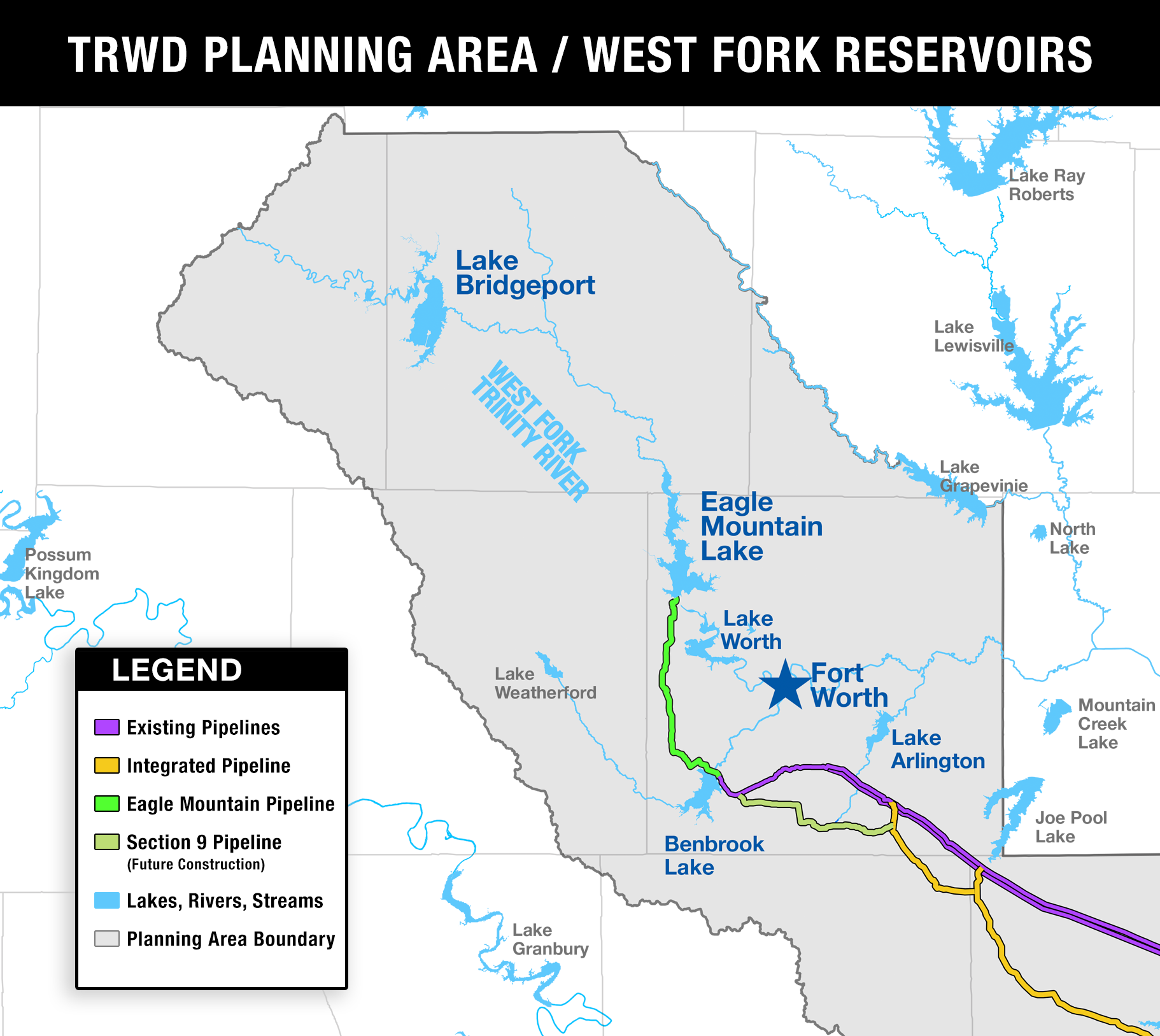
Background: How are Lake Bridgeport, Eagle Mountain Lake, and Lake Worth tied together?
Lake Bridgeport, Eagle Mountain Lake, and Lake Worth were all created by dams built on the same river system – the West Fork of the Trinity River. The primary purposes for each of these reservoirs are water supply and flood control.
The way these lakes line up, releases from Lake Bridgeport flow downstream into Eagle Mountain Lake. Releases from Eagle Mountain flow downstream into Lake Worth. And water flowing out of Lake Worth flows into the West Fork of the Trinity River, which passes just north of downtown Fort Worth before continuing east to Dallas.
Lake Bridgeport and Eagle Mountain Lake have spillway gates that allow for controlled releases from each reservoir before lake levels reach conservation pool elevation. The only way for water to leave Lake Worth, on the other hand, is for the lake to fill up to its conservation elevation, at which point it begins flowing over the spillway.
Tarrant Regional Water District operates these reservoirs as a system. In cases of heavy rainfall, we can use Lake Bridgeport and Eagle Mountain Lake to temporarily hold back water to reduce flooding downstream. On the water supply side, we can release water from Lake Bridgeport and Eagle Mountain Lake to meet demands of municipal water treatment plants that tap into Eagle Mountain and Lake Worth.
Below: Map of Lake Bridgeport, Eagle Mountain Lake, Lake Worth and the West Fork of the Trinity River in relation to Fort Worth.
Comment: We were told by our realtor that Eagle Mountain Lake was a constant level lake.
There are no constant level lakes in North Texas. In fact, all lakes in Texas rely on rainfall and runoff to get replenished. Water levels will continuously fluctuate depending on demands and weather conditions.
Think of a reservoir as a savings account for water supply. Its main purpose is to capture rainwater and store it for future use. During periods of heavy rainfall and low water use, lake levels tend to climb. During times of high demand, high evaporation and low rainfall, lake levels will fall. This is typically more noticeable in the hot, dry summer months.
If you’ve lived in Texas for a few years, you know that when rainfall is in short supply, we can experience extended periods of drought. When that happens, lake levels are sure to drop until the rainfall returns. The only thing that is constant about lake levels in Texas is that they will change over time.
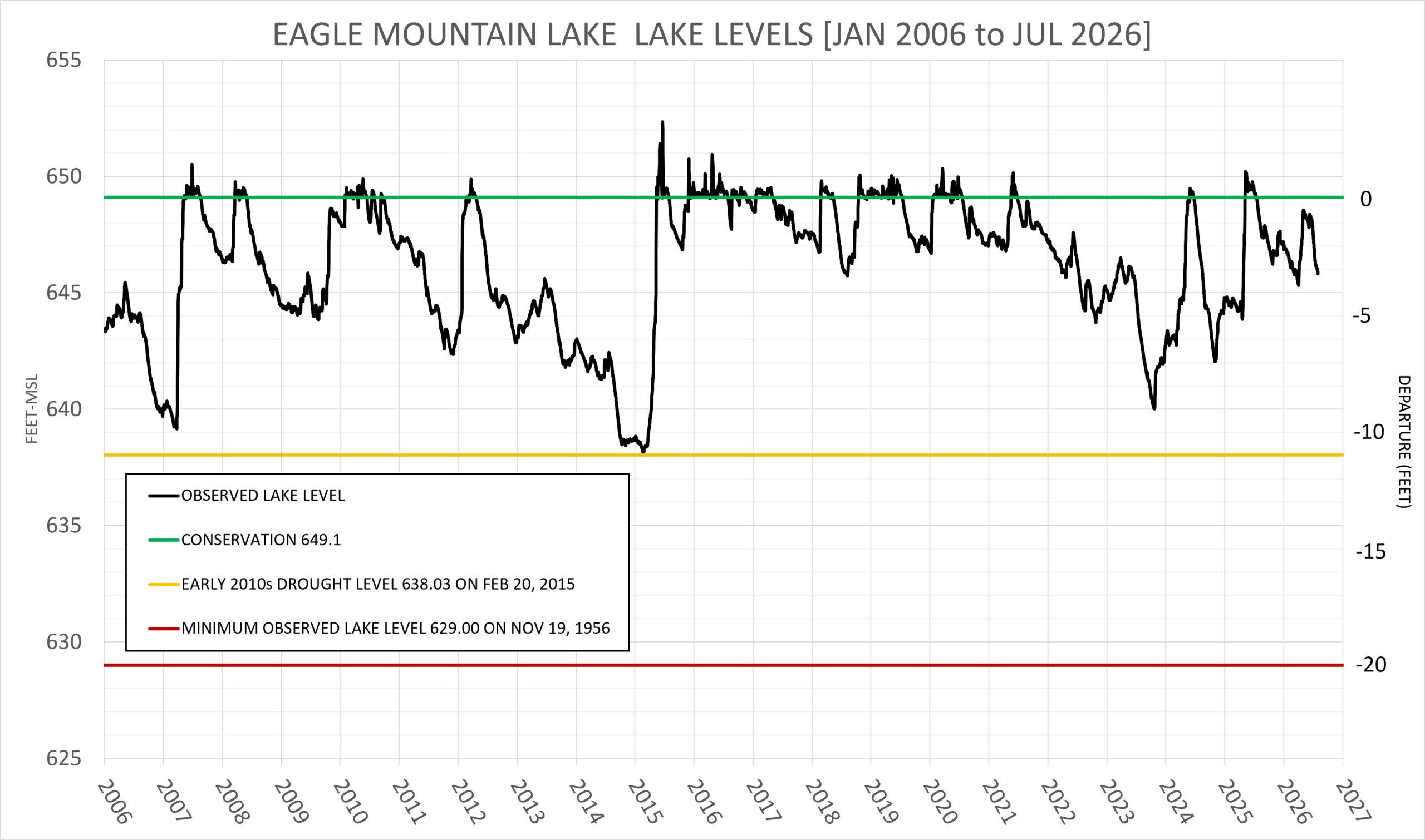
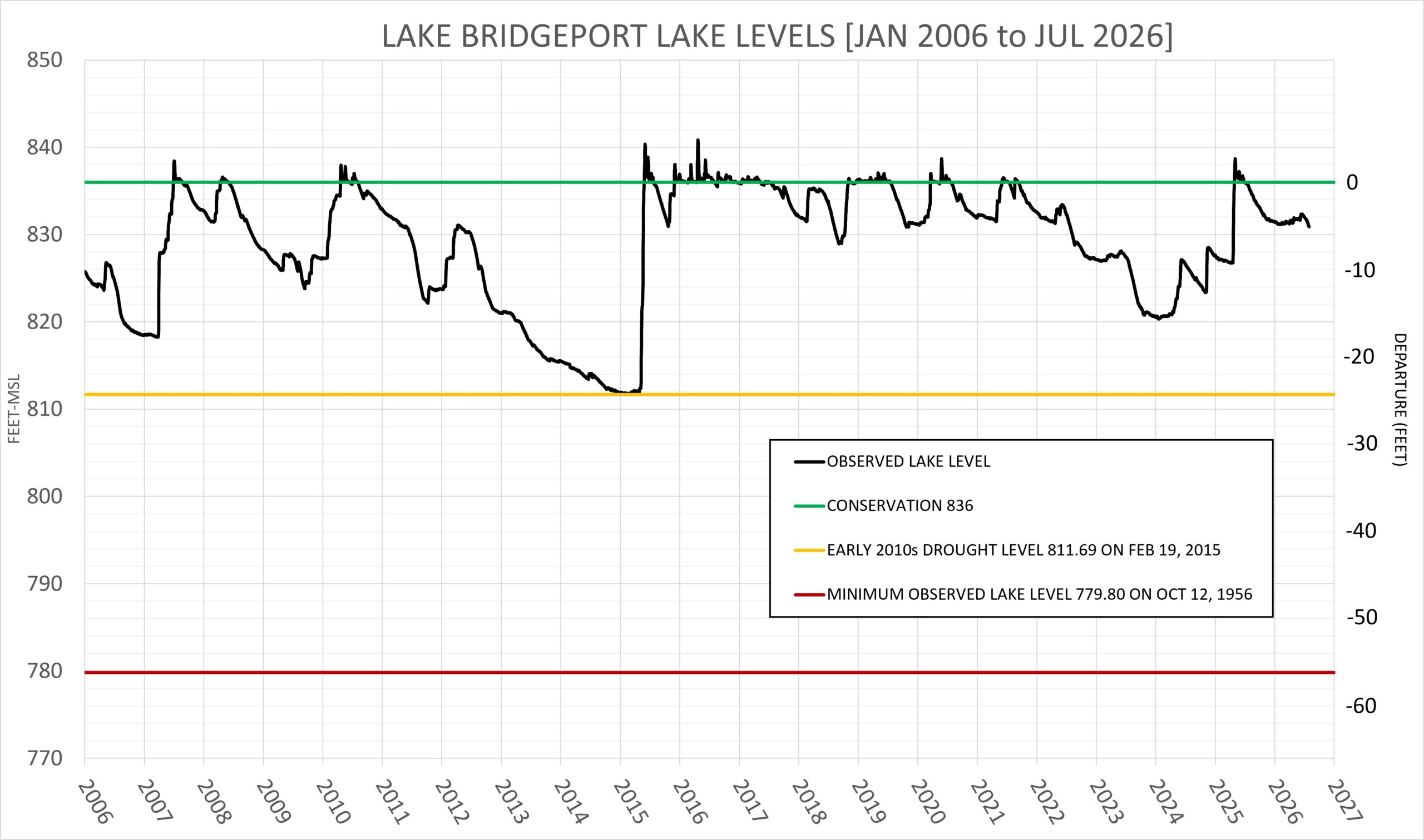
To give you a better idea of how lake levels fluctuate over time, here’s a historical look at lake levels for Eagle Mountain Lake and Lake Bridgeport since 2006.
Does evaporation really influence lake levels that much?
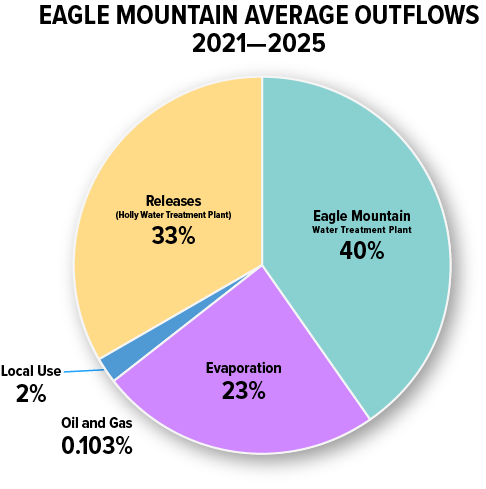
Yes. Evaporation has a major influence on lake levels. In fact, over the course of five years of observations (2021-2025), evaporation accounted for almost a quarter (23%) of the outflows from Eagle Mountain Lake. During the hottest days of summer, evaporation can account for 30 percent or more of the daily decreases in West Fork lake levels.
On a breezy, hot summer day, lake levels can drop as much as 0.5 inches/day, or more than three inches per week. It adds up. So, over the course of a week, we could lose hundreds of millions of gallons from our reservoirs due to evaporation before it ever gets used.
You can keep up with all the factors affecting lake levels, including evaporation, on the daily report published weekdays by our Water Resources Engineering Department on trwd.com.
The pie chart below provides a breakdown of outflows from Eagle Mountain Lake driven by water demands and evaporation (2021-2025):
- 40% of the outflows were due to water demands driven by the Eagle Mountain Water Treatment Plant operated by the Fort Worth Water Department.
- 33% of the outflows were released into Lake Worth to supply the Holly Water Treatment Plant operated by the Fort Worth Water Department.
- 23% of the outflows were attributable to evaporation.
- About 2% went to local water users, such as Springtown and Azle, that divert water out of the lake.
- Water needed for oil and gas production amounted to about 0.10% of total water outflows from Eagle Mountain Lake.
How does the Eagle Mountain Pipeline help lake levels in Eagle Mountain and Lake Bridgeport?
TRWD built the Eagle Mountain Pipeline in 2008 to supplement storage in the West Fork system, which is more prone to drought conditions than our reservoirs in East Texas.
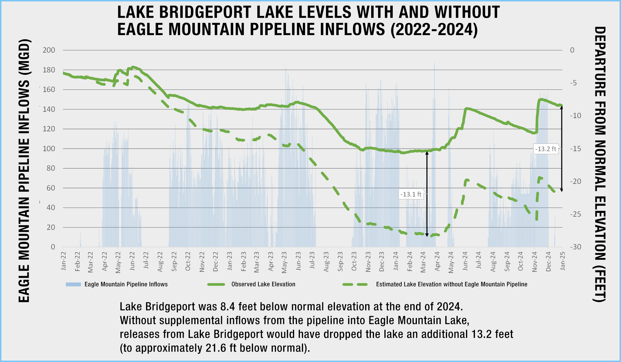
The $170 million, 20-mile pipeline allows the Water District to move water from its East Texas lakes directly into Eagle Mountain Lake. Adding more water to Eagle Mountain Lake through the pipeline reduces the amount of water we have to release from Lake Bridgeport to meet water demands. And that helps us keep more water in Lake Bridgeport.
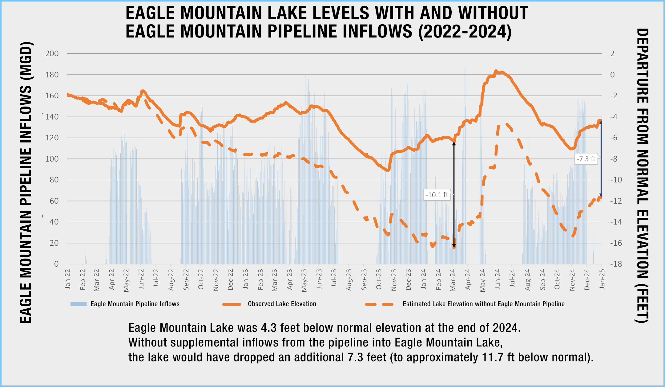
Over the course of three years, from 2022-2024, we moved more water through the pipeline into Eagle Mountain Lake than it received from rainfall and runoff. That’s pretty incredible.
The total volume of water pumped from East Texas into Eagle Mountain Lake (2022-2024) was 60 billion gallons. During that period, lake levels without the pipeline would have fallen twice as much as we observed.
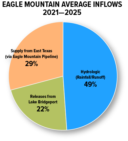
The pie chart below expands the time horizon to a 5-year period and depicts the average breakdown of inflows into Eagle Mountain Lake (2021-2025):
- Rainfall and runoff flowing into Eagle Mountain: 49%
- Volume of water added via pipeline: 29%
- Releases from Lake Bridgeport: 22%
Why is Lake Bridgeport always a lot lower than Eagle Mountain Lake?
That’s not always the case. But a lot of times Lake Bridgeport is indeed lower than Eagle Mountain Lake. Here’s why…
TRWD manages Lake Bridgeport and Eagle Mountain Lake as part of a connected reservoir system. Water is released from Bridgeport to Eagle Mountain when it’s needed to support demands, especially during droughts or summer months when our water use increases.
Lake Bridgeport holds about twice as much water as Eagle Mountain Lake when both lakes are full: 372,000 acre-feet compared to 185,000 acre-feet. Its deeper and more compact basin stores more water per foot of elevation, making it more efficient for long-term storage. So, even when lake levels in Bridgeport are down twice as much as Eagle Mountain, the reservoirs are still about the same percent full.
Eagle Mountain Lake is shallower, and its shape results in water supply intakes being positioned closer to the surface. These intake structures are more vulnerable to falling below operational levels during periods of drought.
To reduce the chances of service interruptions at Eagle Mountain’s water treatment plants, TRWD works to maintain healthy lake levels there. At the same time, releases from Bridgeport are carefully managed to avoid drawing it down too far and impacting its own water intakes.
Operational guidelines are designed to balance these risks, supporting reliable water service across the system without putting one reservoir’s customers at a disadvantage.
Another factor that can play a role in lower lake levels at Lake Bridgeport is that it typically receives less rainfall than Eagle Mountain.
Why are you releasing water from Eagle Mountain Lake when it is already low?
The primary reason for releasing water from Eagle Mountain Lake (when it’s not flooding) is to support the intake for the Holly Water Treatment Plant on Lake Worth. Our goal is to keep lake levels in Lake Worth from dropping below the threshold where it would impact deliveries to the drinking water treatment plant.
In this case, the critical threshold at Lake Worth is four feet below the conservation pool. At that level, the water intake for the Holly Plant would cease to function at 100% capacity, limiting production at one of the City of Fort Worth’s water treatment plants.
We use operational guidelines based on the combined storage levels in Bridgeport and Eagle Mountain to determine how much water is released to maintain lake levels in Lake Worth. The lower the storage in the West Fork water supply reservoirs, the lower Lake Worth will be.
Why can’t you keep more water in Eagle Mountain Lake after it rises above conservation pool?
All the reservoirs in our West Fork system – Lake Bridgeport, Eagle Mountain Lake, and Lake Worth – were built at a time when zoning wasn’t much of a consideration. This resulted in homes that were built within a couple of feet of the conservation pool elevation at each of these lakes, which means there is not much leeway when it comes to rising lake levels.
The lowest house on Lake Bridgeport is 3.0 feet above conservation. At Eagle Mountain Lake, the lowest residence is 2.4 feet above conservation. And at Lake Worth, the first house begins to flood when the lake reaches 3.4 feet above conservation.
Retaining water above the conservation pool in any of these reservoirs longer than necessary reduces their capacity to hold additional floodwater that could be produced by more rainfall.
As you know, weather can be tricky to predict. Releasing the water above conservation pool reduces the chance of flooding if additional rain comes along. For low-lying residences around the lakes, an extra foot of holding capacity can make all the difference between staying dry and getting flooded.
Is there a way to see how much water is being pumped / released from Lake Bridgeport and Eagle Mountain Lake?
Yes. We release a daily report for all our reservoirs on weekdays. The report details changes in lake elevations, volume of water pumped from each lake, volume of water pumped into each lake, water supply releases, flood discharges, evaporation volumes, and precipitation amounts, among other information.
You can find the daily report on our website at: https://www.trwd.com/resources/water-supply/
Why does it seem like the West Fork Reservoirs are almost always less full than your East Texas Reservoirs?
There are multiple reasons that the West Fork Reservoirs are usually less full than our East Texas Reservoirs (Cedar Creek Lake and Richland-Chambers Reservoir).
The first reason has to do with climate. When people say, “Fort Worth is where the west begins,” what they’re really saying is the further west you go, the drier it gets. And that’s so true.
The average annual rainfall at our East Texas Reservoirs ranges between 40-50 inches. As you head west, the range drops off. Average annual rainfall for the western portions of North Texas is between 30-40 inches. Less rainfall and runoff mean the rates at which the West Fork Reservoirs are replenished are lower than that of the East Texas Reservoirs.
You can find monthly and annual precipitation data measured at DFW Airport by the National Weather Service here.
A second reason that the lake levels of our East Texas Reservoirs are usually higher is their size – both watershed size and reservoir size.
The area draining into our East Texas Reservoirs is 1.5 times larger than the area draining into our West Fork Reservoirs. More rainfall over a larger watershed means more runoff, nearly double compared to the West Fork system.
As for reservoir size, Richland-Chambers can store 1,100,000 acre-feet and Cedar Creek Lake has a storage capacity of 645,000 acre-feet. Compare that to Lake Bridgeport and Eagle Mountain, which have storage capacities of 372,000 acre-feet and 185,000 acre-feet, respectively.
We can pull a lot more water from the East Texas Reservoirs without impacting lake levels as dramatically as pulling water out of the West Fork Reservoirs. And that’s why about 80 percent or more of the water we consume in Tarrant County comes from East Texas.
How much of an impact does the oil and gas industry have on West Fork water supplies?
TRWD water sales to the oil and gas industry reached their peak in the 2008-2011 timeframe. At that time, about two percent or less of our total annual water sales were consumed by the oil and gas industry for drilling and fracking wells.
During those peak years, we did supply approximately 1.5 to 2.5 billion gallons of water to oil and gas operations annually. But since the peak, drilling demands have subsided considerably – from billions of gallons to less than 200 million gallons annually district-wide, or less than one percent of TRWD’s total annual water sales.
In the West Fork, the average amount of water used for oil and gas operations amounts to approximately one-tenth of one percent of West Fork water supplies.
Additional sources of information
- Daily Report: https://www.trwd.com/resources/water-supply/
- Lake Level Blog: https://www.trwd.com/category/lake-level-blog/
- Lake Levels: https://trwd.onerain.com/
- WaterDataForTexas: https://www.waterdatafortexas.org/reservoirs/statewide
Last Updated 8/29/2026